Team members of the 2010 Vietnam expedition have compiled the following journal. It reflects their own experiences and stories and therefore the original scripts have been used with minimum change in the editing of the report. All team members contributed photographs in digital format and all photographs in this journal are credited to Vietnam 2010 with the exception of photographs credited to Carsten Peters.
Martin Holroyd
The compilers of this report and members of the expedition agree that any or all of the text in this report may be copied for the purpose of private research.
The reproduction of any photographs is subject to copyright and permission must be sought from the copyright owner.
A VIETNAMESE PERSPECTIVE, A REFLECTIVE ACCOUNT OF MR PHUONG
I joined the joint British – Vietnamese Caving Expedition 2010 in Quang Binh province as an interpreter, being the connection between expedition members and local people and the government. This time was the longest and hardest expedition that I’d ever had in my whole life, but it really was my happiest time when living amongst expert cavers, professional photographers, spent time walking all day long inside tropical forest with green all around, or completely dark, cool cave chamber – everything was completely different to noisy, dusty and polluted city where I’m living. This time, I had a chance to live naturally.
As usual, my work was to contact with local guides to get the latest information about new caves that they have found in the last year. I extracted a lot of new info, some of them were very interesting such about a cave near Lao-Vietnam border line where an US aircraft was shot down and burned, or a valley where has at least two fresh and good entrances which means hopefully for another good caves.In fact, it was. On the trip last year, all I had to do was trekking with expedition members and local guys to make the both sides understand each other – that’s all. This trip was not only just that because I aimed a higher goal: get into a cave and learn how to caving. Before the trip I told Howard about my goal and looking for his help to make my desire become true, and he agreed – what a good old man! This trip I was equipped with very good headlamp, wetsuit, backpack and other equipments which allow a dummy to get out a cave in one piece. I was instructed how to use equipments in right way, how to get in and out a cave safety, and they also taught me about things in jungle and especially inside a cave, how they made, how important they are or how to protect them, not only small things such as tiny stalactites or shiny cave pearls but also the whole jungle and its bio diversity – that’s the way we protect our resources, our environment, our lives. Great experiences, great knowledge I earned through the expedition.
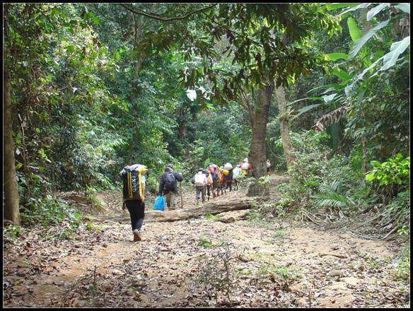
The most things I had to do almost during the trip were how to live inside dense jungle. The Ke Bang Massif in Phong Nha – Ke Bang NP holds a large number of caves inside, but to get to cave entrances requires hard walking inside rugged terrain or even free climb on vertical cliff, with a lot of dangerous and bloody insects moving around. For this task, you must have proper footwear like heavy duty boots, thick socks, etc. Preparing these things was my luck. Thanks to Vietnam footwear and textile industries, I bought a good pair of jungle boots with price of US$ 5, and some good pairs of long socks, all in Hanoi, which protected me perfectly against tricky conditions inside jungle. Before each jungle trip, expedition members equipped me with sleeping and proper caving equipments if the caves are available for me to get in and out safety. Then after each careful preparation, we walked into jungle to find those new cave entrances. Walking inside jungle is not a hard work with me, especially in those days which have monsoon – cool weather and clean air make the trip easier than cloudless and shiny days. While walking, I kept looking for poisonous plants which will cause serious itch for at least a day, depends on how long and how much you touch it; or hungry small insects try to bite me. But thanks to the expert local guides, they always helped me about that. The last thing that I prepare for each jungle trip was my medicines which provide first aid when I got bite, cold, itch, injured or hard breath, such as first aid items, ventolin inhaler for asthma, antihistamines tablets…
In most jungle trips, we started in the morning and had tried our best to reach the nearest campsites to the cave entrance. Sometimes campsite was a good tent used by other jungle men, or a small level area where we are able to hang our hammocks or stretch our sleeping mat; have a large stream nearby or just only some small pools with a lot of tree frog larval. When we reached the campsites we usually had a small time for rest, then we went into nearby jungle to collect firewood, chopped small tree to make temporary tent and cook dinner. Nights in jungle came quite fast, and being tired after a walking day, I always chatted for a short time and get sleep quite fast while jungle men was playing card or fishing (if there was large stream near campsite) until midnight.
Food in the jungle was simple. I ate with both local guys and expedition members sometimes double meal because I can’t do anything with an empty stomach. For Vietnamese food, we always ate rice with pork or fish and vegetable soup. They were tasty, spicy, and if we have another spice instead of sodium glutamate, I could say they’re healthy food. Sometimes I ate pasta, bread, drank English tea with expedition members. Not too much food for my always-empty-stomach, but it brought me a large volume of energy, enough for trekking, caving or climbing. Each time we go for caving, I always took at least 2 packs of Energy Bar or 1 pack of Oreo biscuit because inside a cave always cooler, not counting that sometimes we might swim in cold water. Caving consumes a large volume of energy, so if I lack of extra food, my body temperature will decrease quite rapidly, I will fell asleep and exhausted – dangerous situation. Water was also a problem. Fresh water in jungle always contains a lot of disease agents and it need to be treated before drink. The easiest and most safety way to treat raw water is cook until it boil at 100oC in a few minutes, then put some black tea into it and wait it become cooler. But this treatment need firewood, a lot of time for both cooking and waiting until water is cool enough for drink. Another treatment we used in the trip was put 3 drops of iodine liquid for a litre of raw water and then wait at least 30 minutes for purifying. Water could be put into water bag or bottle, add some iodine drops then put it into backpack and keep walking – it’s easy and simple. For better taste, I always put 2-3 orange flavor multi-vitamins tablets for 1.5l water bag.
Caver is not only who does physical activities such as walking, climbing, survey… but also need sharp thinking about the environment. In karsts area, the most dangerous things are thunder storms with heavy rain because they could cause very strong streams or even flash floods which will block your way or even leave you no chance to survive if you stay near the stream. In rainy season, it’s even worse with all day raining, high water level and strong streams – that’s why caving expeditions are always at the end of dry season. In the last photographic trip in Hang Son Doong, we caught 2 thunder storms, one happened when we were still on the cave entrance, one when we were moving deeper inside the cave. The first thunder storm made us hurry to move inside the cave and cross the underground river before its water level rose too high. The second one happened when we were doing photography in the first doline, and then caused two dramatic underground water falls. I thought that was my first and last chance to see that most beautiful scene.
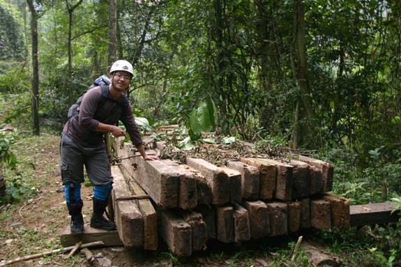
Get involved with the expedition up to 7 weeks, I finally realized how serious are illegal logging and hunting in here. In jungle of Minh Hoa district, I saw a lot of high quality hard wood, some trees with dimension up to a meter were being chopped and carried out of jungle by local men. It’s hard to imagine how a 50kg man can carry up to 100kg wood walking on rugged terrain, but it was real. In Phong Nha – Ke Bang NP, due to highly protection made by the government and forest rangers, there is no serious logging like that, but I saw a lot local men got into jungle to collect a precious wood which Chinese traders can pay up to US$ 100 for each kilograms. I asked and got the answer that local men just collect this kind of wood from dead tree, just because there was no longer alive tree in this area. Wild animal hunting and trapping were even worse. I can easily find a restaurant which serves fresh food made from wild animals in wherever we stay. In my opinion, I think this is the biggest things that the government of Quang Binh province must face if they want to make their NP as a best place for ecotourists, wildlife researchers.
THE FILMING OF HANG SON DOONG
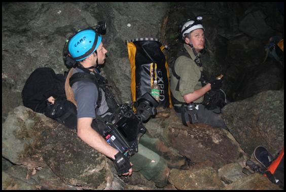
I realised in England what a task to film Hang Son Doong was going to be but I never expected it quite to be the headache it was going to cause. We had done some cave training with the film crew but they were very inexperienced and had little SRT knowledge. We had taken them down Lancaster Hole the week before we left and it was only then the film crew realized that caves are completely dark!! Thus armed with this knowledge we set out to film what turns out to be the largest cave passage in the world. Fortunately Hang Son Doong has a number of daylight shafts which would enable the film crew ample light in a number of stunning sections of the cave.
We met with our guides and porters in Son Trach to hire a large contingent for the duration of the film. The film crew of 5 included a producer, an assistant, 2 cameramen and a sound recordist. On top of that we had National Geographic Magazine which included a writer, a photographer and his assistant. Our team of 7 persons included Dr Anette Becher who was to play the role of Biologist. We also had 4 members from Hanoi University of Science which included 2 botanists and Mr Hieu and Mr Phai who as usual were essential to keep the show on the road. Also in the party was Mr Long a man from the Ministry of Foreign Affairs who looked after the film crew. Just when we thought we had a team the National park insisted that we had a park ranger with us to look after us.
 Thus 50 people set off from Son Trach laden down with equipment for the making of the film for National Geographical TV. We planned to camp in Hang En on route to Hang Son Doong and the film crew and myself set off early to try and beat the rush. Our 23 porters were heavily loaded carrying up to 40kg and often very bulky packs. At this stage I really fancied hiding and running away from the mayhem but unfortunately we had all signed contracts so there was no way out.
After over 5 hours we finally made it to Hang En with all our equipment. We set up camp and left the film crew to rest whilst we resurveyed this immense cave with accurate laser measuring devices. Our survey in 1994 shows the smaller entrance where we camped to be 25m wide. This was now measured at 80m wide oops!!! We soon surveyed the 1.6k to the huge exit and made our way back to the team for a well earned dinner.I could not sleep well that night with all the possible problems going through my head but managed a few hours and woke up at 5.30 at first light to arrange the next stage of our journey.
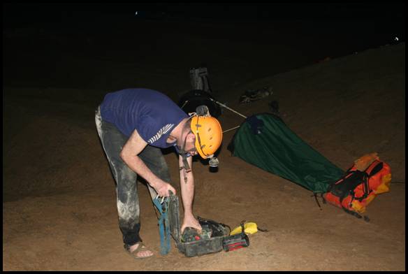
Our plan was to go to Hang Son Doong and set up an underground camp near the entrance with 2 generators so we could recharge the camera batteries and any other lighting equipment we had used. We had sent back 10 porters so we had to relay the huge mass of equipment in stages down to Hang Son Doong. We managed all but 6 loads which would arrive the next day with a bit of luck. However the first underground food bag was left as one of the loads so we hastily had to rearrange the food stocks. When cooking underground for 8 days with an underground party of 20 people not including porters is a nightmare especially when stoves and pans are hidden in one of the 50 bags transported. Sweeney and Clarky rigged the first underground pitch of 60m in such a way that it was just possible for us to descend without using SRT equipment. However the film crew were safely watched down the pitch and escorted to our first camp down by the river on a nice sandy floor. It was a little cosy but adequate. The National Geographical Magazine team sensibly opted to camp at the entrance away from the masses.
The next day the plan was to film the river crossing and the initial sections of this huge cave. This went to plan but the day was a long one and involved numerous heavy loads being carried around 3k in the cave to the first doline ‘Watch Out for Dinosaurs’. Trying to make the river crossing look exciting with the low water levels was difficult and with head mounted cam we intrepidly played actors in what was a simple crossing. Meals were a bit sparse and the film crew insisted on double the amounts of high energy bars for lunch that we had accounted for. This ‘Bear Grylls’ film crew had certainly not met with conditions like this before as well as having to put up constant piss taking that the team lashed out towards them. However they persevered and day 2 was over.
It was harder trying to get them out of bed in the morning but I forced them awake for what was to be a difficult day for all, which was moving camp to the deep underground camp 2 at the far end of the cave. This was a grueling day for all the film crew. This also was the first chance I had of seeing the majority of the cave. It is quite a stunning bit of passage and everyone was overwhelmed by the size and splendor of this amazing cave.The American writer for Nat Geo Mark turned out to be a star, assisting the porters and encouraging them to carry numerous loads to the final camp. He is quite a character having climbed Everest and many other name dropping places. His thoughts on Hang Son Doong were that it was the most impressive geological feature he had ever seen and should definitely be classed as a natural wonder of the world. I was a little doubtful about Mark at first but he turned out to be a real team player and an invaluable member of the team. He did lots of interviews with all the team members without being too annoying and hopefully his story in the magazine will not be too over the top.
I had a little spat with the producer late in the day when certain loads were missing but finally it was resolved and we all made camp late in the evening a little tired and certainly sweaty. The camp complete with generator and filming gear was set up and a nice meal followed before everyone had an early night. The next day I again woke early and cajoled the team out of bed with a brew. Sweeney and Clarky were to set off to start the bolting of the Great Wall of Vietnam whilst the rest of us were to be involved in filming in the huge and impressive ‘Garden of Edam’. Darryl the American geologist a real nice quiet lad was to be the film star and because of his lecturing experience he fitted in the role brilliant. Anette acted as the biologist and set traps in the underground jungle with the film crew following her around. The ‘Garden of Edam’ is quite breathtaking place with cliffs 350m high and 175m wide. In this lost world trees grow to perhaps 40m high and the jungle is very dense with typical jungle foliage. Our botanist started his work looking for new plants in this jungle and the film crew staggered around in the jungle being tripped and caught by every vine. I took a team to push some leads left by last year’s expedition. We managed to survey and explore just over 300m before the side passage sadly sumped. Hang Son Doong is really just too big to have side passages. We found a white spider and a white scorpion in this side passage which the Nat Geo boys hope to photograph at a later date. Darryl the geologist an excellent caver proved very useful with his knowledge and he explained various features associated with the major fault the cave was on. He also explained that the river in the wet season floods the cave to 100m deep and the river flows at 35kph and becomes 2,000 cumecs minimum in the wet season. I imagine it’s quite a sight but not really practical unless you had suicidal tendencies.
We all arrived back in camp expecting Sweeney and Clarky to have made it up the great wall. However they didn’t make it back until much later due to the difficulties they encountered. After a 12 hour bolting epic Sweeney had climbed around 50m in extremely poor conditions. The entire wall was calcite and the first 15m was very thin with mud behind. He nearly had to abort on a number of occasions but he somehow managed to persevere and finally obtained some more solid calcite which the thunder bolts managed to secure more decent anchorage. A very muddy pair arrived back in camp very tired after the day’s work with no end in sight to the wall.
The next morning Sweeney and Clarky returned to the wall whilst the rest of the team were filmed in mock surveying as well as long interviews in sight of daylight with myself playing the lead character. This took an age mainly because we are certainly not actors which by this time the film crew had managed to grasp. We were let loose by the film crew and managed to do a photographic trip around camp. Whilst on this trip a huge cheer could be heard from further down the passage which we correctly guessed to be Sweeny having finally climbed the ‘Great Wall of Vietnam’. The film crew took off again down the incredibly muddy ’Paschendale’ to obtain footage of the returning heroes as well as some film of Sweeny bolting. They all arrived back in camp again to be filmed with myself greeting them as if I didn’t know what had happened. My great role as actor will no doubt be an Oscar winner no matter what the rest of the team felt!!!
After another minimal meal we had a long serious chat with the film crew about the wall climb. Patrick the producer was pleased to hear that I recommended that the film crew should not ascend the wall due to the technical difficulties. The rebelays were free hanging and the rope was not in the best condition and we
would not be able to remain at rebelays to assist them on changeovers. Thus the
end of the cave was beyond the capabilities of the film crew and they decided I
would be the cameraman for the rest of the trip. I had a quick 5 minute lesson with a smaller camera and both cameramen gave me tips on what and what not to do. Having never used a movie camera before I felt a little pressured to say the least especially when the producer stated that my footage would be the final part of the film with the credits!! No pressure!!
The film crew would again work with Darryl who was turning into a Robert De Niro and excellent in front of camera and Anette our Biologist and totty for the Film.
 We meanwhile set off down Passchendaele again to be filmed starting the climb until out of sight. The bolt route by Sweeny and Clarky was a real necky push and it turned out to be nearly 90m high all in crappy calcite. We had 2m of rope spare at the top and the final 40m was on 9mm climbing rope with numerous abrasions points. We all safely ascended and set off surveying and photographing the amazing passage. A height was done from the bottom of the wall to the roof of the cave and the 196m reading was greeted with loud cheers. This was set up for my camera and the film crew was pleased to have what they term the ‘money shot’. They also gave a head cam to Sweeny which may have proved a mistake with his narration of Mr Floppy and various other quotes which will not appear on any film. We surveyed just over 300m until the huge passage exited. We all exited as instructed by the now demanding cameraman myself hopefully obtaining the final sequence of shots for the cave. We obtained a GPS reading at the exit and realized that we were only 3k from a road. We were solely tempted to leave the film crew but sense prevailed and we retreated back into the cave. We found a calcited animal possibly a bear high on a stal boss and I again became cameraman instructing lighting and acting. I was quite getting into the role before they all told me to piss off. I never saw this happen with the film crew!!! We finally descended the bolt route safely and made our way back to camp for another meagre meal.
The next day we planned to leave and hoped to reach the river camp before dark. The porters were fantastic and were far better underground than any of us with huge loads and plastic sandals. We in high tech grippy boots could not keep up even though we had far lighter loads. After much more filming Patrick finally decided he had enough footage and we made our way back slowly to camp, with all the film crew doing well and encouraged we would leave the cave the next day. Carsten the Nat Geo photographer left our camp for the surface and it was 3 hours later when surface phoned to me asking about his whereabouts. Deb and Sweeny were sent as a rescue party and found him off route with no light. He was escorted back to camp; his light sorted and sent on his way again. His ‘boy’ Robbie Shone had not been looking after him properly so much piss taking was sent his way. Unfortunately our food had been taken out of the cave by our porters so our final meal underground was looking a bit sparse. I had however hidden a few spare rations at camp and we managed to produce another small meal for the team. By this time the film crew was happy and a good wash and swim was had in the river underground to clear the filth that had accumulated from the past few days.
We escorted the film crew and equipment out the following morning and made a dash for the road. Only an interview with Mr Khanh the original finder of the cave was done this day to complete the film. Our porters were loaded up again on the surface and a long walk back to the road began. After 6 hours we reached the road only to find no transport. Mr Hieu managed to find a motorbike and after driving 26k managed a weak mobile signal and instructed the 2 minibuses to come and pick up the weary and filthy team. We squeezed into the transport and even managed a beery session before collapsing in a real bed for the night.
Was it a success? We wait and see but at least we all had an amazing time in this truly wonderful cave. Would I do it again? Definitely NO.
Howard Limbert
GREAT WALL OF VIETNAM
The Great Wall of Vietnam, or at least climbing up it, had been uppermost in my thoughts for most of the preceding year.Despite never actually having seen it,I’d formed a picture of the alleged 15m high calcite wall as being something like Malham Cove:solid, pure, flowstone, possibly climbable, bound on either side by wings of limestone rock. Reality, however, was something completely different. The damn thing was huge, no visible rock whatsoever, the base a horrible muddy platform at the end of Passchendaele Passage & overhanging for the first 8m or so.
A crack on the right looked initially as the most obvious line, a quick, Chaplin-esqe slither around the base failed to provide any better option. Deciding we might as well make a start, a calcite boss proves a handy step-up to drill the first hole. Thinking expansion bolts will probably split the calcite, instead we’d have a supply of 120mm & 160mm Thunder Bolts. These look somewhat like the old Warthog ice-screws with the advantage of needing only an 8mm bit but requiring hangers with 12mm holes rather than the normal 10mm alloy caving hangers. The other disadvantage was they need installing with a ratchet & their performance was something of an unknown.
Tapping the calcite did little to inspire confidence but an opening in the surface revealed a more solid sub-strata.Hole drilled, bolt & hanger ratcheted in, etrier clipped & step up.Unfortunately this was to be the only solid bolt for the next 3m’s as the wall above consisted of a thin 2mm calcite skim over mud, the drill bit sliding straight in with very little resistance. Left & right failed to offer anything more solid but 2 bolts side by side allowed a very careful move up. Not unexpectedly, once level with the bolts, rather than pulling downwards on them, they start to slide out! Panicked instructions to Howard for a tight line make the situation a little less precarious & the bolts are weighted once more. 2 more bolts drilled just 1m up & the process is repeated, 1 of the lower bolts slides out in passing. What looks to be better calcite can be seen 2m higher but this means continuing upward & decking from about 8m if it all goes wrong.Slump down on bolts & re-assess.The misery of the situation is increased by water dribbling down from above, Ronnie’s & thermals are now thoroughly soaked.
8m up seems a long, long way when you’re 5k into a cave, 10,000kaway from home,hanging from a bolt installed in something with the consistency of wet putty. Not happy & not sure I’ve enough spare underwear back at camp to continue. Very near to binning it & just hang their considering how to best tell Howard & Mark (Nat Geo journalist) patiently waiting below.As a last resort use pick end of Petzl hammer to bash away the mud revealing a more gravelly lower strata. (Over the next couple of days this constant hammering results in my developing tennis elbow in my left arm) Encouraging shouts from below to the effect it sounds as though I am hitting something more solid. 2 more bolts & then 2 more. Keep looking only upwards. At arm’s length can now reach where the calcite changes colour & has a smoother, more solid texture.Fantastic, drilling now results in a proper biting noise & finally the bolt ratchets in tight & deep.
Just now a question of bolting up bit by bit. Resort to interspersing the longer bolts with 2 interim shorter bolts. Every 10 bolts stop, leave last 3 in, de-rig the 7 below & start again. 10 hours later & its apparent the 15m wall height estimate might have been somewhat optimistic. Can see a ledge above that we should be able to use as a hanging belay stance but run out of bolts some 4m short & call it a day having used 57m of rope. Both of us tired, Howard’s in some discomfort as he’s been taking my weight wearing a normal Avanti harness whilst I’d bought the superb padded Falcon just for this climb.
Next day we pinch the last available 27m srt rope from its current washing line duties, don slimy, damp, clothes from the day before & set off down Passchendaele once more.Delicately up the rope, conscious as to the numerous rub points, calcite dinner plates rain down on Howard.3 bolts then at the sloping belay ledge via having a paddy at Carsten who has turned up to take photos. Carsten’s shouted instructions to his flash assistant’s means Howard can’t hear me asking to take in slack as I intersperse bolting with climbing & this is making me crabby. Shouting down, I invoke the traditional “F” chant of the terminally nervous, Robbie gets the message & suggests to Carsten they should leave.
At the ledge put in 3 horizontal bolts & Howard prussiks up. 2 cavers, 3 bolts, big drop.(As an after note, 1 of these bolts sheers at the head when we de-rig the pitch 8 weeks later). Route continues up & to the right & time saved by being able to occasionally climb couple of metres.Mark turns up at bottom of climb & his light seems a very long way away.
The wall continues vertical for 8m before the angle reduces. Steady progress onto a flat 15m long terrace leading to what looks to be a final 20m wall. Bolting, intermittent climbing & peeling off before it levels off & onto a 45% slope leading up & up.Delicately pitter patter upwards dragging the climbing rope behind, just as it is running out the slope levels & we are up! Large boulder makes a convenient final belay.
By now Mark has joined Howard on the2nd belay stance & both prussik up.Ahead, big cave passage leads towards an exit into daylight about 3-400m forward. Handshakes, whoops of joy & we radio in to confirm line now rigged. Advise base that we’re happy to stop at this point & return to continue exploration as a group but message comes back saying it makes more sense for us to see if we can actually exit the cave or if ahead is simply a doline leading to further passage. Great! Mark asks how we feel & suspect he expects we’ll say ecstatic, overjoyed. The honest answer is the predominant feeling is simply relief, relief that we are up & safe.
The 3 of us walk along a 50m x 50m gour filled passage full of pearls & Howard comes up with the namePearl Harbour in honour of Mark who is blown away by the sheer beauty of this new, unexplored passage. It is fantastic, large, sparkling with calcite, very grippy. Up over a ridge (later trip would discover a large, calcited animal skeleton here) & down easy slope crossing a wet weather, but presently dry, lake.Long rubble slope leads up into daylight.Exiting into dense jungle, we quickly pick up a GPS reading before pushing forward.We can see across a valley but no obvious path. (HSD Exit eventually proves to be 90 mins from the road as opposed to the 1.5 days walk to HSD Ent) Back into the cave & discover, having been out of the cave for only 10 mins for the first time in 5 days, I’ve been leached & blood is dripping down my arm.
Sit in the daylight entrance zone to snack. It doesn’t get any better than this.
Sweeny
HANG SON DOONG EXTENSIONS 2010
Several leads remained to be checked following the initial exploration in 2009. Some passage dimensions also had to be confirmed due to the disto’s being unable to measure the large distances encountered. The average passage width is 80m and average height 80-100m. Around the swimming pool, and approaching Passchendaele, the passage is over 130m wide.
The Garden of Edam was measured at over 163m wide.
A side passage at ‘In Dog we Trust’ was surveyed for a further 250m over rimstone pools, to a steeply descending gour slope which sumped in all directions at its base. A white scorpion and white spider were noted in a calcite choke.
At the lake near the entrance, a small inlet passage was followed that was partly explored in 2009 to a low airspace section. This was pushed through a low airspace, into an ascending passage with fine flowstone. After 100m, this intersected a larger flood prone passage which ended in a sump after 50m.
From the top of the Great Wall of Vietnam, 300m of passage was surveyed to a relatively small exit. The passage was dry and well decorated with many cave pearls. It was 70m wide. A calcited animal skeleton was discovered on top of a large stal boss. This could be the So’n Duo’ng (mountain cow) of which there are numerous hoof prints in the mud, or possibly a bear as suggested by one of the guides.
The exit was at 165m altitude as measured by GPS, was into an obvious valley, but with no obvious path out, and heavily vegetated.
At the Great Wall of Vietnam, the passage is 199m high.
High Level Cave Development
Dr Vu Van Phai of Hanoi University of Science has identified 5 levels of cave development in the Ke Bang Massif (see below). Level 1 or 0m is taken as the modern stream cave level. Caves explored on this expedition in the area above Hang En suggest there is probably a sixth level at 350-400m above stream level.
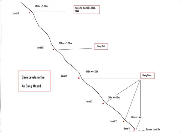
Hang Ho Nui was first explored in 2007. At an altitude of over 500m the cave is large and well decorated and 420m long.It is over 300m higher than the river level, which in this case is Hang En at 180m.
Hang Doi, located above Hang Khe Ry is 350m above stream level. It was explored in 2001, is 450m long and 24m deep. The cave has a mud floor with many formations.
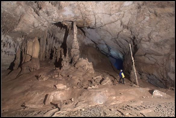
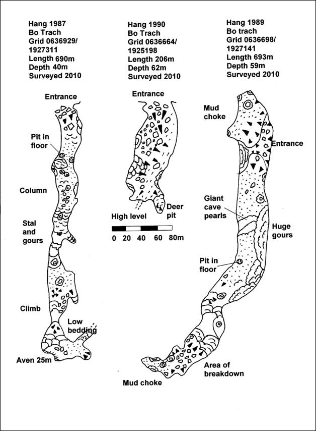
The caves explored in 2010, Hang 1989, Hang 1987 and Hang 1990 (named after the year they were first visited by Khanh) are between 350m and 380m above stream level.
Hang 1990 is situated at the end of a valley. A large entrance in a cliff leads down steeply to a well decorated chamber, with many cave pearls. At the end there is extensive calcite and a small drop to a mud floor with no way on. The cave is 60m deep and 690m long.
Hang 1987 is situated halfway up a cliff; this entrance also drops steeply over boulders to a large calcited passage. There are old dry gour pools with unusual mushroom shaped formations. The cave enters a mud floored chamber with a climb up though flowstones to a calcite choke. There are many fine columns. The cave is 916m long and 75m deep.
Hang 1989 is also a large entrance halfway up a cliff. Descending steeply over boulders and flowstone the cave levels out into an extremely well decorated cave. There are many fine flowstones and curtains, as well as an area of extremely large cave pearls. The cave ends in a calcite choke. The cave is 206m long and 62m deep.
These high level caves whilst not as long as the river systems are very interesting for their extensive and often unusual formations.
Deb Limbert
BEDROCK GEOLOGY
Hang Son Doong is formed in the Ke Bang massif, which exposes a section of Devonian (360-416 My) to Permo-Carboniferous (251-360 My) limestones that were originally deposited in the Paleotethys ocean.These limestones are now part of the Truong Son Fold Belt, a zone of intensely folded rocks that extends northwest across the northern half of Vietnam and into northern Laos.These rocks were folded during a period of mountain formation in the Early Triassic (240-250 My) known as the Indosinian orogeny that is associated with closure of the Paleotethys ocean and assembly of the Indochina tectonic block (Lepvrier et al. 2004).The limestones of the Ke Bang massif are surrounded by insoluble rocks to the east and south.These include Carboniferous to Triassic metamorphosed crystalline rocks that form mountains to the northeast, and much younger Cretaceous (145-65 My) red sandstone and mudstone to the south.Some Cretaceous redbeds are also preserved near the temple to the northwest of Hang Son Doong.These Cretaceous red rocks represent continental sedimentation.
Beginning at about 50 My ago, during the Paleogene, India collided into Asia.Associated with that collision, what is now the Indochina block was extruded southeastward out of Asia along massive strike-slip faults.At that time minor strike-slip faults also formed throughout the Indochina block.A series of strike-slip faults trending NW-SE are widely observed in north-central Vietnam, as well as regionally.These faults are associated with extrusion along the NW-SE trending Red River fault that passes through Hanoi into the Gulf of Tonkin (Rangin et al., 1995).A second, somewhat younger set of stike-slip faults trends N-S, and cuts the older faults.The N-S faults probably date to the Neogene (beginning 23 My ago), and may be associated with opening of the South China Sea (Rangin et al., 1995).
The bedrock geology has had a strong influence on the formation of Hang Son Doong.The Permo-Carboniferous rocks are generally massive to thickly bedded, and are formed of relatively pure calcium carbonate that is conducive to cave formation.At the cave, the rocks are dipping approximately 20-30 degrees to the north.At only one place in the cave (Watch Out for Dinosaurs) was a section of thinly-bedded limestone observed, and this was associated with passage collapse. Interbedded cherts are generally rare, except in localized bands.Both the Paleogene and Neogene faults control the passage geometry.Hang Son Doong formed primarily along a single N-S fault, with a truncated passage (The Alcove) extending SE along an older fault.
Cave description
1. Geology
Besides its size, one of the defining characteristics of Hang Son Doong is that it is profoundly straight and generally lacking side passages (with one exception at The Alcove). This is because the cave has formed along a N-S fault.The fault is well-exposed in the ceiling and walls, and is almost never out of view.It is subvertical and usually consists of 1-2 major strands.The walls of the cave also often expose a fault breccia developed in the limestone.This breccia consists of striking black and white calcium carbonate that forms angular, sharply-defined patterns.The patterns tend to be tooth-like near minor faults, merging into an almost kaleidoscopic background.Overall, the fault breccia seems to define a zone approximately 100 meters across, and may have helped to control the width of the cave.
The cave has been subject to two massive collapses to daylight.The southern collapse doline is named Watch Out for Dinosaurs (WOFD).It is 110 meters across at the base, and is colonized by thin forest.The walls of the WOFD collapse are the only place in the cave that expose thinly-bedded chert-bearing limestones.The doline collapse almost certainly occurred here due to the weakness of the rocks.The northern collapse doline at Garden of Edam (GOE) is considerably larger, 163 meters across at the base.A thicker forest covers the collapse pile.The rocks at GOE are thickly bedded, and so collapse here is not due solely to rock strength.Instead, it is apparent that GOE formed at the intersection of two major faults.The main cave is formed along a N-S fault, presumably Neogene in age.A tributary passage that is filled by an earlier collapse formed along a NW-SE trending fault, presumably of Paleogene age.GOE is found at the intersection of these two faults, where the ceiling would have been weakened both by its extra width at the passage intersection, as well as by the presence of two faults in the ceiling which would promote collapse of the unsupported blocks between them.
2. Hydrology
Hang Son Doong can be conveniently broken into three smaller units.The southern section, south of WOFD, the central section between the WOFD and GOE collapse dolines, and the northern section, north of GOE.
a. Southern section
The southern section of the cave actively takes water today.The passage has many indications of annual flooding, including actively dissolving breakdown, re-dissolving speleothem, and coarse fluvial sediment derived from outside the cave, as evidenced by abundant red sand and mud from the Cretaceous rocks and crystalline fragments from the Triassic rocks.
Base-level flow at the time of our visit was estimated to be about 10 m3/s, although no direct measurements were taken.Peak flow was estimated from scallops widely distributed on the floor and walls at the first river crossing.The scallop dimension can be related to flow velocity, and probably represents conditions under peak annual flow.Scallop lengths were measured at 10 places each on the floor and walls, chosen at random over an area of several square meters, and are reported in Table 1.
The standard method for interpreting scallop dimensions comes from Curl (1974).He suggests taking a weighted mean of the scallop dimensions (the Sauter average).For the floor and walls the weighted mean dimensions are 46 and 35 mm, respectively.The scallop dimension is then related to the flow velocity through a scallop Reynolds number and the ‘law of the wall’, a widely-used relation in hydraulics.
Table 1. Scallop dimensions at river crossing, in mm.
| Floor | Wall |
| 35 | 35 |
| 25 | 35 |
| 30 | 35 |
| 35 | 28 |
| 24 | 37 |
| 50 | 32 |
| 55 | 34 |
| 60 | 35 |
| 45 | 28 |
| 34 | 40 |
For flow velocity calculations, I assumed that the flooded passage at the river crossing was 35 meters wide and 10 meters tall.I calculated flow velocity for parallel walls 10 meters apart.I assumed a water viscosity of 1 cp, consistent with a water temperature of 20°C.For 35 mm scallops, the calculated water velocity is 1.2 m/s, or 4.4 km/hr.This corresponds to a discharge of 400-450 m3/s.
The peak annual discharge of rivers in central Vietnam is not widely available in the English literature, or is not known to me.However, there is a report for discharge of the Tra Khuc river, approximately 400 km to the southeast, available online (http://flood.dpri.kyoto-u.ac.jp/ihp_rsc/riverCatalogue/Vol_04/10_Vietnam-6.pdf).The Tra Khuc river has a catchment area of 3240 km2, and annual rainfall ranging from 1.8-3.6 meters across the watershed.The mean maximum discharge for this catchment is approximately 7000 m3/s, corresponding to a specific discharge of about 2.1 m3/s per km2.If the Tra Khuc river is an appropriate analog for the Hang Son Doong watershed, then the discharge estimated in the cave is consistent with an upstream drainage area of about 200 km2.
Active flooding of the southern section of the cave is evident all the way to the WOFD doline collapse.During floods, water is apparently dammed behind the collapse pile, filling the passage approximately 100 meters deep, to the elevation of the Level Playing Fields.The Level Playing Fields is a flat surface on the top of a gour sequence, capped by a layer of sand. The sand is active during the annual flood. Footprints from 2009 were not visible in 2010.There are small channels that are apparently active on this surface, and the sand shows evidence of water flow. Floodwater apparently drains today through a bypass called the Oxbow, where it goes to a lower level of the cave.
There is evidence that the southern section of the cave has a long history of being filled with ponded water during the rainy season.The lower half of the cave contains a thick deposit of laminated muds and fine sands.These sediments are best exposed underneath the formation called the Hand of Dog (HOD), which is composed of a porous combination of gypsum and carbonate.The massive speleothems in the vicinity of HOD all show evidence of faulting, slipping, and wholesale collapse into the main passage as the formations are undercut and lubricated by the mud banks on which they formed.Two samples were taken to ascertain the age of the sediments at HOD: one for paleomagnetism, and another for cosmogenic nuclide burial dating.Dating results are reported in detail in a later section, but the sediments here are likely younger than about 300,000 years old.
b. Central section
The central section of the cave is fossil, with no evidence of river flow in the recent geologic past.The area near the WOFD collapse doline has a fantastic set of gours formed from ceiling dripwater.Elsewhere in this section there are speleothems indicative of dripwater, but no externally-derived sediment and no evidence of flooding.
c. Northern section
The northern section of the cave is mostly fossil passage.There is some evidence of flooding in the geologic past in the vicinity of The Alcove in the GOE collapse doline.An unconsolidated deposit of large cobbles and small rounded boulders indicate very rapid streamflow through a passage near floor level just to the south of The Alcove.However, all of the cobbles and boulders are composed of limestone.I observed no externally-derived sediment.This indicates that the water is either coming from a different source, or that the sediment has been filtered and is not transported to this part of the cave.This deposit does not represent simply a downstream extension of the same river that entered the southern section.The sediment is also clearly not associated with the time of speleogenesis, when a river would have traveled through the entire length of the cave.
At Camp II (north of The Cormorant) there are several meters of laminated silt indicative of flooding.The source of the water is likely a rising sump.There is no evidence of externally-derived sediment, so this water is either from a local source or it is filtered from the main river below.The silts are of unknown age, but the surface shows signs of active transport, so they are probably flooded episodically today.
Continuing north, the Passchendaele section carries water even under base flow conditions.The presence of cave blindfish indicates persistent streamflow.The sediments here are several meters thick, and consist primarily of wet mud.A bathtub ring extends several meters above the sediments, illustrating the limit of annual flooding.Floodwater here is likely of two sources: a rising sump and dripwater.The Passchendaele section is beneath a doline on the surface that funnels dripwater into the cave, even during the dry season.The Great Wall of Vietnam is a muddy flowstone that has accumulated beneath the doline.The main source of water here is probably the same as at Camp II.There is no evidence of externally-derived sediment.
Geochronology
A dedicated effort was made to search for samples that could constrain the age of either the cave or the sediments within it.Suitable samples for dating caves are often found in sediments filling pockets on the cave wall, or high-level passages.Speleothem of pure calcite can be dated by U-series or U-Pb under suitable conditions.Despite a careful search, no such sediments were found.However, two sedimentary fills that postdate cave formation were found and samples were collected for dating.These were 1) the laminated silts behind WOFD at Hand of Dog, and 2) a passage-filling breccia at The Alcove.
1. Hand of Dog.
Laminated silt and mud beneath the speleothem at Hand of Dog were deposited in a quiet water environment, probably in ponded water behind a dam formed by the collapse at WOFD.The sediments thus probably date to the time of doline collapse.They are much younger than the cave itself, and have little bearing on the time of speleogenesis.
Two types of samples were collected.Three cubes of sediment were collected in oriented plastic boxes for paleomagnetic analysis.Each cube consists of a 1 inch (2.54 cm) square pressed into an oriented surface.The cube is 5/8 inch (1.6 cm) deep.Three samples were taken on a vertical face oriented N12°E.Each cube was marked, and oriented using a bubble level.The samples were sent to Josep Pares at CENIEH (Centro Nacional de Investigación sobre la Evolución Humana), Burgos, Spain for analysis.All three samples were determined to be magnetically normal, indicating that they were deposited less than 780,000 years ago.
A sample of silt was also collected for cosmogenic nuclide burial dating.This dating method is based on the decay of cosmogenic 26Al and 10Be in the mineral quartz after deposition in the cave (Granger and Muzikar, 2001).Successful dating requires that there be a measurable quantity of these nuclides, and that the aluminum concentration in the quartz be low(10-100 ppm).The silt sample was found to contain abundant quartz, however the aluminum content was moderately high (~250 ppm).The measurements were therefore not very precise. Cosmogenic nuclide data are reported in Table 2, and age calculations are reported in Table 3.The age of sediment at Hand of Dog was determined to be young, -0.27 +/- 0.32.Even though the age is negative (a physical impossibility), it overlaps within error with zero, and is thus statistically normal for a young sample.A sensible maximum age for the sediments is two standard errors older than the calculated age.The age of the sediments is therefore determined at 95% confidence to be younger than 0.37 My.
Both paleomagnetic and cosmogenic data indicate that the sediments at HOD are young.The best estimate for the timing of collapse at WOFD is within the past 370,000 years.I anticipate measuring this sample again as part of an experimental effort to improve the precision of 26Al measurements, so there is the possibility that the precision of this age will improve in the future.
2. The Alcove
The Alcove is a filled side passage that intersected Hang Son Doong at the Garden of Edam collapse doline.The Alcove represents a passage essentially as large as that of the main cave, and would have been a major tributary passage at the time of cave formation.The cave likely carried water sourced from a stream passing through the village along the trail to Hang En.At The Alcove, the passage is entirely filled with a breakdown breccia containing abundant externally-derived sediment.The passage collapse here therefore occurred after the time of speleogenesis, but while the river was still occupying the main passage.
A sample of sediment was collected here for cosmogenic nuclide burial dating.Results are reported in Table 2 and Table 3.This sample also contained a moderately high (~150 ppm) aluminum concentration, precluding very accurate dating.Moreover, the sample was surprising old, meaning that the cosmogenic 26Al concentration was very low.The 26Al measurement is therefore subject to very high uncertainty.The burial age of this sample is 3.0 +2.0/-1.0 My, bracketing the age of the sediment to 2-5 My.As with the sample from Hand of Dog, I anticipate re-measuring this sample in the near future in an experimental effort to improve 26Al precision.
Although the uncertainty in the burial age at The Alcove is disappointingly high, the result clearly points to the antiquity of the cave, placing speleogenesis in the Pliocene or possibly the latest Miocene.Effort should be made to re-date this sample if at all possible.
Table 2. Cosmogenic nuclide analysis
|
Sample |
mass Qtz |
[Al] |
Be spike |
26Al/27Al |
10Be/9Be* |
[26Al] |
[10Be] |
|
(g) |
(mg/g) |
(mg) |
(x 10-15) |
(x 10-15) |
(106 atoms/g) |
(106 atoms/g) |
|
|
HOD |
39.274 |
240 |
362 |
79.2 ± 11.5 |
89.2 ± 5 |
0.424 ± 0.065 |
0.055 ± 0.003 |
|
Alcove |
43.086 |
146 |
401 |
10.9 ± 6.4 |
36.3 ± 6.3 |
0.036 ± 0.021 |
0.023 ± 0.004 |
*Measured against standard KNSTD07.
Table 3. Burial age calculations
|
Sample |
26Al/10Be |
Burial age* |
|
(My) |
||
|
HOD |
7.704 ± 1.260 |
-0.28 ± 0.32 |
|
Alcove |
1.572 ± 0.966 |
3.05 +1.98/-0.99 |
*Burial age calculated using radioactive meanlives for 26Al and 10Be of 1.02 and 2.005 My.Production rates are taken as 4.1 and 27.9 atoms/g/yr for latitude 17.5°N and altitude 0.4 km.
Speleogenesis
There are several observations of local geomorphology and geology that lead to a general theory of speleogenesis for Hang Son Doong.Most tellingly, a high-level paleo-valley is sculpted across the surface, draining westward (Figure 1).This paleo-valley is carved into the limestone, but pre-dates cave formation.This implies that there was no subterranean outlet for the water from the basin, or else caves would surely have carried the water.The basin is surrounded to the east by metamorphic and crystalline rocks, and to the south by Cretaceous redbeds.A portion of the northern boundary of the watershed also abuts onto Cretaceous redbeds, preventing cave formation.The remainder of the watershed is surrounded by large faults.I suggest that these faults served as aquicludes, preventing water from passing through, and stymieing cave development.In particular, the fault along the ‘Road 20’ valley would have blocked water flow towards the Son River.It was only when this fault was breached, probably by incision of a surface stream in the valley to which Hang Son Doong exits to the north, that a hydrologic outlet was available for the watershed.At that time, the water draining the Hang Son Doong watershed would have been perched in a riverbed perhaps 200 meters above the new base level where the fault was breached.Water immediately began forming caves to this outlet.The fastest flow path to the outlet was along a pre-existing N-S (Paleogene) fault, and another NW-SE (Neogene) fault.The cave expanded rapidly, taking the entire discharge of the watershed by wholesale capture of the surface river.Cave formation was probably rapid, as suggested by the lack of tributary passages and the volume of water that must have been captured.
Summary of observations
Hang Son Doong formed as a result of stream capture along a pre-existing N-S trending fault.The capture likely occurred due to breaching of a different NE-trending fault that blocked water flow until sometime during the Pliocene to latest Miocene (2-5 My).The cave today takes an estimated peak annual discharge of 400-450 m3/s, consistent with a drainage area of 200 km2.The massive size of the cave is likely due to several factors.1) The limestone here is generally thickly bedded and able to support a wide ceiling.2) The cave has developed to a fairly uniform width, possibly influenced by the width of the fault breccia zone in which it formed. Cave enlargement has thus been primarily vertical rather than horizontal.3) The cave has few tributaries that would weaken the ceiling.In cases where either conditions (1) or (3) are violated, the cave has collapsed.The age of the collapses is probably variable, but Watch Out for Dinosaurs likely collapsed during the past 370,000 years.
References
Curl, R. L., 1974, Deducing flow velocity in cave conduits from scallops, National Speleological Society Bulletin, 36: 1-5.
Granger, D.E, and Muzikar, P.F., 2001, Dating sediment burial with in situ-produced cosmogenic nuclides: Theory, techniques, and limitations, Earth and Planetary Science Letters, 188:269-281.
Lepvrier, C., Maluski, H., Van Tich, Vu, Leyreloup, A., Phan Truong Thi, Nguyen Van Vuong, 2004, The Early Triassic Indosinian orogeny in Vietnam (Truong Son Belt and Kontum Massif); implications for the geodynamic evolution of Indochina, Tectonophysics, 393:87-118.
Rangin, C., Huchon, P., Le Pichon, X., Bellon, H., Lepvrier, C., Roques, D., Nguyên Dinh Hoe, Phan Van Quynh, 1995, Cenozoic deformation of central and south Vietnam, Tectonophysics, 251:179-196.
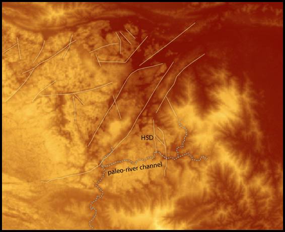
Figure 1.
Digital Elevation Model showing topography in the Ke Bang massif in the vicinity of Hang Son Doong.Major lineations (faults) are highlighted in yellow.Note the prevailing tendency of N-S and NW-SE trending faults, as well as the younger NE-trending major faults.A karst paleovalley is highlighted in blue.The valley does not take water today, but predates cave development.Hang Son Doong (HSD) formed near the intersection of a N-S fault with the paleovalley.At the time of speleogenesis the cave pirated water from the paleo-river and carried it along the N-S fault to discharge ultimately into the Son River.
Darryl Granger
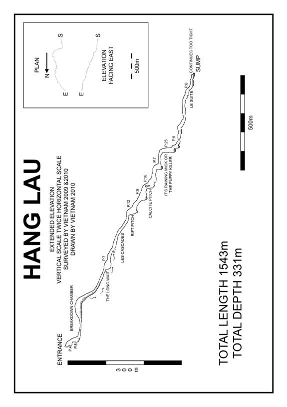
RETURNING TO HANG LAU
In 2009 Helen Brooke, Martin Colledge, and Adam Spillane explored Hang Lau for 500m and to a depth of 100m, abandoning exploration due to lack of time and lack of rope at the top of a short pitch.
This was Martin and Adam’s prime objective for 2010. Hang Lau is located at 590m asl, 3-4 hours walk east of the Chay. It has a strong draught going in, and takes a small stream, even in the wet season.
In 2010 Martin and Adam, accompanied by Mick Nunwick and Ian Watson set off to continue the exploration of Hang Lau, to a conclusion with further leads to the North as a back-up plan. This plan was thrown into disarray at the first hurdle when we were denied entry to the National Park due to a missing piece of the permit. A quick discussion determined that we would visit the northern caves first, accessed from outside the park, trusting that a permit would be in place when we needed to exit. We walked up a good track and were soon at a campsite, having lost Watto on the way due to his prior foot injury. Martin was convinced that the area was very familiar, and GPS locations of other caves were too close for comfort. That evening we inspected the entrance and Martin satisfied himself that he had never been there before.
Day 2 was joined bright and early with a refreshed team, bar Mick who had a lot to learn of hammock sleeping. We returned to the cave, Hang Noi Bu, which was explored to the limits of our rope, at nearly 100m deep, via snakes and rats, the subject of another report. While underground, one of our guides, Mr. Ky explored a nearby cave, Dry Cave, to 300m with no way on.
Day 3 dawned with striking camp and the walk to Hang Lau, arriving shortly after lunch, on a walk that had taken us close to Hang Nuoc Lanh. A new camp constructed on a gloomy afternoon we set off into the doline to Hang Lai, a short dry high level remnant of the Hang Lau system. Back to camp to prepare for the long awaited return to Hang Lau in the morning.
Day 4 saw a refreshed Adam and Martin, awoken with breakfast by an ever alert Mick, awake for hours after bedding down in a hammock/bath of his own design. A 25min stroll downhill led to the well remembered entrance to Hang Lau, this year the entrance was free-climbed, the first climb re-rigged as a pitch, and the second pitch rigged from a minute thread instead of via a scary traverse. Progress was fast via the 2 flat out wet crawls, now thankfully enlarged by monsoon floods, the breakdown chamber and more crawls to the head of a pitch, last year’s terminus, and now named The Long Wait. Here Martin took over the rigging. The pitch quickly rigged from a thread into a chamber apparently blocked by calcite at its lower end. The calcite though had not sealed completely and a steep climb allowed us to rejoin the stream. From here 200m of cascades, and roped climbs led us to a short pitch into a deep pool, more pitches and swims followed, until we were again halted at the head of a pitch, rope had run out and we had to return to Son Trach.
Two days later and the same team, plus Andy, and interpreter Phuong set off for Hang Lau. Phuong was abandoned close to the road to make his own way back to Son Trach, but 5 hours later we were at camp, with enough rope to push Hang Lau to the huge fault that would give us access to the source of the Chay.
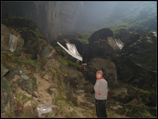
Mick and Andy set off, with drill and bolts, rigging. Martin followed as target, with Watto on MDL, and Adam on book. We were over 200m down and 1000m in, surely this trip would see us to glory. Inlets joined, the cave got wetter, still descending at 1in5. A convoluted route through boulders dropped into a deep pool. A 25m very wet pitch landed in a deep pool. A crawl under calcite deposited you into a deep pool. A theme was emerging. Then we caught Mick and Andy. The cave had ended, in a deep pool. A sump took all the water; the draught disappeared through a too tight rift. Hang Lau was at an end. A fabulous sporting cave, with aquaria of white fish, giant tadpoles, yellow long-legged spiders, white woodlice and pinkish cave-waterfall climbing fish. We set off out, Martin in the lead and Adam following, de-rigging as we went. Photographs planned for the exit.
Half way up the 25m pitch Watto’s good leg went bad, cramping up. Leaving no option but to use his bad foot and cause great pain. Martin and Adam, blissfully unaware sat and waited. Adam went up a further pitch, to set up a shot. Martin waited. Just as Martin thought about going back down, the 3 arrived with Watto in agony. Andy came up next to flashes and camera, and we set a hauling system. Mick and Martin came up next, followed by Watto with an assisted ascent. Climbs were passed by brute force and arm strength, pitches with an assisted haul. Eventually we reached the exit, 10 hours underground, and began the slog uphill, vines assisting on the steeper, muddier parts.
Hang Lau ended. Over 1500m long and over 330m deep. .
Adam Spillane
EIGHT DAY WALK
RB, DL, HL, PM, TW 1.04.-8.04 2010
Ten minutes had passed on landing in Son Trach and Howard was looking at me enthusiastically, “you’ve not been up to Hang En yet have you!”
“No” I replied “but I’d love to”
“Great were going in the morning looking for some high level stuff above Hang Khe Ry. 8 days, get your shit together and well have a leisurely start in the morning”
Day 1
Admittedly a steady walk into the impressive valley of Hang En. A through trip with Snablet and an early night in the outrageous Hang En.
Day 2
Forward to Airplane cave. Howard had visited this cave in 2007 and gave us a blow by blow account of the walk up which turned out to be almost factually perfect. Had it not been for the fact the path had overgrown somewhat over the last two years, the journey would have been navigation problem free. Much scratching around in the undergrowth and traverses over razor sharp pinnacle Karst we arrived at Airplane cave unscathed.
“Has anyone any water left” said Trevor (or Spuff as he likes to be known)
“No” I replied
“It’s ok we can get drips from the roof” Said Howard
“What fucking drips” said Trevor?
“Oh yeah, shit” said Howard.
 Several frantic minutes passed looking about for Gour pools full of water from the last monsoon season, no water was to be found so we placed every empty vessel we owned under the ten drips the 100 meter wide cave was delivering to us. A quick tally up of our total water supply gleaned we had one and a half litres plus Howards half a bottle of coke. Brilliant!
Two hours later our wonderful porters got us sorted after constructing drip collectors out of shower curtains. A whole pan of water was available for our evening meal, plus half a pan for a brew! An evening foray into the cave to look at a suspicious passage left in 2007; ended thanks to the power of Hope Light Technology.
Day 3 – Search for Hang 1990
The drip collectors were eagerly inspected at 7 am they had collected enough for a breakfast and a brew plus a litre maybe two… for our days walk. Several hours over varied terrain including vegetated pinnacle Karst, many short climbs and continuous up and down hills brought us to a small clearing in the Jungle. On inspection of the map Snablet informed us that we had covered a grand total of 400 metres in just less than five hours, a trend that would prove to continue. Another trend that continued was the fact that that we had another camp with no water. Several hours of water hunting and still no water, don’t panic reader we were in the capable hands of porters who clearly knew how to find water via many other methods other than the conventional western tap. A small logging campaign was launched on the surrounding Banana and vine population, by noon we were bathing in purple liquor spewing from the latter. (Banana trees rock, Vines roll)
Day 4
Search for a cave last visited by Kang twenty years ago, Hang 1990, to quote Sweeny “What could go wrong” well nothing actually. Another walk through vegetated pinnacle Karst a through trip en- route and we arrived at a rather large entrance. A steep descent down through house sized boulders dropped us into a large chamber surveyed for several hundred metres; sadly choking with large amounts of old calcite forming huge flow stone pillars columns and blockages. A high level passage 30 meters of the floor enticed the way on but without a bucket of sky hooks and a flying carpet it was not to be. Return to camp to bathe in the purple liquor of the banana plantations, and maybe a vine night cap, hoorah!
Day 5
Locate another blip in the memory of Kang, twenty years previously he had also visited another two caves in the near vicinity of Ho Nui. We set forth again across unrelenting terrain via many sporting climbs, caterpillars, and spiky stuff until we arrived at another impressive entrance. An afternoon trip into Hang 1987 rewarded the team with many impressive formations and large passages again sadly ending in large flow and calcite blockages. However we were lucky boys and girls this cave had many old Gours holding litres and litres of Nouc Lan. After drowning our prune like bodies in tang we stayed up and partied till 8pm!
Day 6
A day trip to Hang 1989, after a short traverse over razor karst vegetation and the odd climb ( not that odd just slightly odd ) and another fine entrance another near Kilometer of old fossil passage ended up in a calcite choke. Again the team was rewarded with superb passage formations and atmosphere in large 30 x 50 Quang Binh Cave. Return to Hang 1987 for refreshments and packing for home! “God I’m enjoying this” said Trevor
Day 7
Return home via pinnacle Karst, climbs, rattan and scrub, home being Hang En
Day 8
Son Trach; Nems, Bah Bah Bah and chips “God I’m enjoying this said Trevor”
Summary
8 days were spent walking, crawling, stumbling, climbing, hopping, around in a kilometer square exploring caves between 500/ 550m always approached via a 700 meter col,all ending in large blockages of calcite flows, gours and stal build up. A remote, beautifully superb part of the Ke Bang massive explored “that’s that bastard ticked off” said Robbie.
Rob Burke
XUONG VALLEY
We had noticed the striking features of this area on the map for many a year. Having talked to Darryl an American geologist who pointed out this enormous fault from NASA images he had obtained we made great attempts to access this area. Finally we obtained guides under the leadership of Mr Khanh our trusty guide from previous expeditions who knew the area. We planned for an eight day recce into the area with 7 porters. The starting point is the track that leads to Hang Vom a major discovery from 1992/94. We soon left the track and crossed the river and met a good flat path which meandered for an hour near the bank of the river. A good rest stop was reached before a sharp ascent up to a col; this was via a very steep gulley for around 300m. The temperatures were rising and a good sweat was on by the time we reached the col at over 450 asl. Again a good path continued through superb jungle that was quite open by Vietnam standards. A group of monkeys were then seen by the guides who have incredible knowledge and spot things loads before we do. The monkeys chucked a few sticks at us before departing further into the jungle. I spotted a hornbill flying overhead and the hoards of butterflies made the journey a real pleasure. After about 5 hours walking we reached our camp for the night. Again the water situation was dire. This year is an El Nino year and the jungle is very dry and only a small squalid puddle was available to quench 12 persons in our team. Many of the jungle plants were showing signs of lack of water but at least we were promised more water at our next camp.
The views from this camp are tremendous and we had reached the start of the fault that comes all the way from the Xuong valley and heads towards the Chay river resurgence. If a cave could be found in this area we could have a major system on our hands. Surrounded by huge cliffs overlooking a large doline our camp was in a fine situation, however no obvious caves were known by our guides at this location.
The next day dawned hot and sunny and we started early on what turned out to be a 10 hour walk. We followed the huge fault mainly traversing up and over a number of cols thankfully on a very good path. A snake was encountered, a pit viper along the way which the Nat Geo photographers took a liking to. We didn’t so we left them to their world. They finally caught us up at another resting camp again without water. We had again drunk all our rations and with one of the porters becoming very ill with vomiting and diarrhea the pace was slow. We shared out the ill porters load and continued towards the promised water. Finally our camp was reached and the water source again a small pool which looked awful and full of evil wasps and horse flies. A camp was erected by the porters and hammocks placed for the duration. The temperatures were in the high 30’s and the team was very lethargic and soon ready for bed after a long hard day. Finally after around 7pm the temperature dropped and all had a good night’s sleep. The next day we were to visit 2 dry caves whilst the rest of the porters would search for caves. The Xuong valley is a very impressive place an old riverbed at an altitude of approx 280m surrounded by huge cliffs and surely a place for a major cave. We were told that in the wet season the whole valley around 4k wide floods to 4m high. The route from the valley upstream leads into Laos and takes around 10 days. We were told of a large river and caves over 10 hours walk up the valley but that was not to be for this trip out but for future years. Our first cave was reached about 1 hour from camp and involved a very steep walk to 450m on the cliff at the end of the valley. Again we had to resort to drinking from vines during this ascent. The cave was a disappointment and chocked in boulders after only 75m.We descended from the cliff off we went up again to what appeared to be a promising looking cave.Although quite large with a 50m wide entrance the cave was in fact just a large alcove full of swifts. The view however made up for this and a stunning sight up the Xuong valley and towards Laos was obtained. Looking up this valley we just could realize the scale of the place and what potential for major caves in this part of the world. However this was not to be one of them and we returned to camp hot and sweaty. A number of shafts had been found by our guides for us to check out and we started with the ones nearest camp. The first a small 17m deep shaft was soon descended only to finish in clean washed boulders. Another similar one was also checked out with the same disappointing results close by. A return to camp was then made hoping for better things tomorrow. Again the water situation was dire. Other teams of jungle men had arrived at this place that is the only water for 10 hours away and they had taken a good share of the available dubious water. Lots of iodine was used in our drink bottles during the next couple of days. Thankfully the porter who was ill on the way in was now well and we planned the next day for more shaft bashing armed with 1x 50m 9mm rope and 2 slings!!
We were told of a 100m shaft with a good wind 2 hours walk away but with our limited resources of rope we had to leave it for another day. Our guides talked about another large cave as well as a river cave over 10 hours away. In these extremely hot conditions with very little water these also were left for future expeditions. We decided to try our luck again at a few more shafts the porters had found. The first looked very promising and had a reasonable draught but again sadly choked at 70m deep. The draught was in fact not present at any depth and was just circulating wind from another entrance. The final shaft was again choked in the all too familiar fashion and the future for shaft bashing in this area seems very limited.
The area of the Xuong valley has immense potential for huge caves. To achieve any success it would take a major undertaking with a team having to be equipped for around 10 days and be willing to walk in for around 4 days to set up a camp near a good water source. This area near the talked about river must be the key to the finding of the huge cave system that must exist in this very remote part of the Ke Bang massif.We will try and send out our guides before we return on our next expedition to do more work and find us entrances that hopefully will yield success.
The 2 day walk back we just managed to do in one long day. The camps water had dried up so we had no choice to do the 2 day walk in one. A very tired and dry team finally emerged from the jungle to be met by our drivers who kindly brought soft drinks and beer to the road head.
Howard Limbert
VUC TANG’S 1ST VISIT 2010
Last year a team left Hang Tang with a small question mark on the survey – a small un-descended wet pitch directly below the main chamber. Surprisingly no-one seemed too positive about potential for great caving below the great entrance series but the question mark was there and it had to be finished. After our initial discovery, Tangs shaft kept me awake at night between the years 2007 and ’09 and I was disappointed to learn last year that 250m of passage was all that was below. Surely a cave of that size must be going somewhere big? If I was attached to only one trip this year it would hopefully be to Tang.
After some quickly fixed permit problems Sweeny, Martin and I set off on a 5 day adventure with Carsten and Robbie trailing, our Nat Geo photography lads. The porter team was led by Tang and Du, with these guys in charge we had a drinking team to be reckoned with! With a caving team of only 3, we still managed to drag a group of 12 lads up the hill to base camp.
Although Tang kept trying to insist that the shaft camp was 2, 6, 8 hours walk still and we MUST stay in an interim camp for the night we finally rocked up to base camp after 5 hours. It would seem that for the first time the porters were playing for time. We set up base and got on the lash with the jungle lads, rice wine and chilies!
At the top of the shaft we put in a bolt on the opposite wall so that a deviation could be set, ensuring no rope rub and less missiles dropping from the take off ledge. With a full rack of bags attached below us all we set off down the shaft. What a sight to behold, certainly an arse twitcher of a pitch! 180 metres drop with a cloud at the bottom where the shaft meets the main chamber. With Sweeny re-rigging a new rope onto old bolts I took down the old rope, and what a mess it was. The way down is hard to rig safely. The rock is broken, the rock isn’t always solid limestone and there is loose stuff everywhere. Sweeny added a couple more re-belays and after an hour or two we were down in camp.
We had some cutting and chopping of the old rope to do to before we could rig further down the cave. Sweens and Martin had already begun to set up camp under the overhang so I set off back up the pitch to bring down more gear. With the camera crew in tow there was lots of luggage! The camp is 30metres back from the bottom of the pitch. It is safe from bombs and is truly incredible. In the morning you wake up in you hammock looking directly up the shaft to the daylight.
The evening was spent drinking brews, organizing kit and taking photos with Nat Geo. Carsten’s photos are amazing, there is no doubt about it, he will build 3 or 4 frames into a shot that we would normally only put one in… And for a German, well he’s actually an ok dude! So we forgave him even when bulbs were blowing up (quite literally!) in our faces. Some good photos were achieved, doing the entrance series the justice it deserves. The evening was spent mainly in amazement of Carsten’s knowledge of snakes; he played with some sort of (small) viper for hours, a viper whose bed was at the end of Holroyd’s bed, much to Sweeny’s and my amusement!
The next morning the light was perfect (!) so we took more photos and the set off with rope, drill and rigging kit to drop the question marked pitch. On arrival at the wet crawl Martin discovered a more obvious and dry way down so off I set with bolting kit and rope to drop 3 pitches, back to back. The first pitch a straight ‘Y’ hang down 13m to a broken chamber, a tight a horribly sharp pitch ensued, 9 metres to a traverse above a 6m drop. We dropped into a beautiful phreatic series where we took off all SRT kit and waded through water to a breakdown area adorned with hanging death. Some of the car size boulders seemed to float in mid air, I whispered “sssh” to the lads following, scared to death that what was above may drop at any minute! We passed this particularly sketchy section often dropping into pools to pass the worst parts. Popping out into a streamway 10 metres wide by 20m high, we rubbed our hands together and set off in search of glory whooping our way down the stream passage. After a while the stream dropped into a proper streamway but the main way on was up a huge boulder slope and a big black hole. The black hole turned out to be a continuation of the main chamber, the original waterway, a large high level fossil series which we hit at a t junction. We decided that downstream was right so we headed off across the sharp cave coral and boulders following this 20m by 20m excellent passage. 2 huge stals, black and white were passed into a superb gour hall with a 40m alcove and a draught. Passing through we hit yet another series of breakdown and another climb up into the continuation. The climbs here were dodgy at best, house sized boulders glued together ready to go at any minute. Carefully Martin chose the up route, Sweeny chose the down route and I stood as still as possible to see which was might be best. Both went into a higher level continuation and a beautiful gour and flowstone passage. After 100m it ended at a pitch head, we could see down to 25m with a black hole beneath. Could we hear a stream down there? With our time almost out we left a great lead to leave for a returning party. With a 19m rope for a survey tape we started out. Each length was “N N N NINETEEN!”
More photos and a camp evacuation saw the team back at the jungle camp 3 days and 3 nights since we left Son Trach. Carsten wanted to photograph the fire flies in camp much to everyone’s annoyance – “Turn that light out, MARTIN, TURN YOUR LIGHT OUT!” A startled Martin grunted a reply to Carsten who immediately took offence and decided the only way to pay back Martins disobedience would be to catch the noisiest jungle Cicada and zip it into Martins hammock where he was trying to read. Well, well, well. I haven’t laughed that hard in a long time.
Our team was keen for an immediate return hopefully with some of the lads from the other team. However since they also had a going cave with none of them keen to give up their place and concede the caves priority and mix the teams up we put Tang on the back burner. Again I would have to wait to find out what was going on down there.
VUC TANG’S 2ND VISIT 2010
So, after a few days rescuing puppies in (then) Quang Binhs deepest cave Hang Lau, Howard sent Mick, Adam and I back to Tang to finish the project. We planned a super light weight drilling trip with minimal rations and kit to go out for 3 nights. It took some persuading but finally Tang and Phong relented and agreed to getting us all the way to the shaft before 1400h. We spoke at length about the trip, planned it meticulously and I’m sure the other 2 guys had a restless night of anticipation as well, to this remote and serious shaft.
When we arrived at the drop off point with the porters Adam decided that “his back was too bad to go” leaving us in an awkward position. Should we carry on as a pair, or return to Son Trach to try and bulk up our small team? The problems in my mind were 1) the remoteness of the shaft, 2) the extremely serious rigging and descent of the main pitch and 3) having to de-tackle 200m of rope over 8 re-belays on a very loose and un-predictable pitch with just us two. I knew we had over 150m of rope down there that needed to come out, as well as fuel, stoves, food, liquid, first aid, camp kit. The list was endless! Mick was not swayed at all, he was going caving! Adams advice was “I’ve been in more remote places…” So, I guess it was on.
Mick and I pushed the porters hard on the walk in. We needed a quick arrival at the shaft so that we could start getting gear in. Our planned 6 hours in saw us at the shaft within 3. Mick was a machine! On the previous visit I only wanted to descend with 20kg at once as I knew we had to get the old rope down as well. With Micks assurance that he had abseiled in the past with 2 bags of concrete and heaps of scaffolding I figured I might as well get on with it. With 2 huge sacks, a drill and rigging kit I set off down. All of the anchors looked ok. A couple were suspect but backed up with other bolts. I re-plugged the bottom bolts and dropped to the chamber floor. Home sweet home! Mick came down, completely aghast. Amazed that he hadn’t realised what an awesome place we were coming too he was super keen to get on with the pushing. We set up camp and had a brew. It was 1430 – time to go push a few pitches! We set off to descend the pitches knowing we were on for a long day. Maybe we played down how great the caving was here because Mick was gob smacked at the size and style of where we were. We got to the top of the 25m pitch and I set off with the drill to see what was below. A Y hang, a few giggles from Mick at my apprentice style rigging, a re-belay and a landing saw us onto a large gallery platform above what appeared to be a huge streamway. A loud stream was echoing all around us so we leap frogged the bolting effort and Mick set off to the front. We dropped onto a steep ramp and then down another 20 odd metres to land atop a pile of boulders. We had an upstream and a downstream, YES, YOU DANCER! Passing a large and beautiful black stal we climbed down into the water. The passage was large, 15 by 15 and running pretty steeply down. We quickly checked upstream, blocked by boulders (again!) and headed down. After some serious boulder climbing and wet bits we hit another area of breakdown. The stream disappears into the floor here where you can see a younger rift passage taking the flow, but no way through. AGH!
We checked further along the fault. There was an inlet coming in but ascended quickly to an aven. There was another hanging death boulder choke that if you had a spare week might follow through to the water passage below, we didn’t have the time or man power so decided to push on back up. What a day. It was late and we had been up since 0530. We headed back to camp, food and bed. We were both disgusted to discover the mother or father of Carsten’s pit viper. What a treat, a metre long pit viper sat watching us in camp! It certainly took the edge off of the awe of the camp. Sweeny had commented that this was a camp you would never forget, that it was truly incredible. We all agreed, until now!
The next day we set off back to start the survey. It was quickly finished and we set off to the “upstream” of the fossil passage above the slope earlier mentioned. Our shortest survey leg was 40m; we followed this large but highly dangerous passage through more breakdowns to an ending at a climb that was too dangerous to push, too much breakdown, too many loose boulders. The draught was lost by now so we headed out, de-rigging as we went. Arriving back at camp we packed huge loads and set off up the pitch, added in another re-belay and left the porters with the first loads of tackle. On inspection of the bolts for the 3rd time Mick noticed a couple that were pulling out with grey goo oozing out of the holes. We immediately backed these up with new spits and carried on. We descended for a final time, ate, slept, and set off out on the de-rig. Mick set off with a huge load, my load was large enough but I had the task of de-tackling and hauling up the 200m rope. With plenty of cursing – aimed towards Adam and his bad back we made it back to the surface. Tang and Phong met us with rice wine and we started our walk out. I think we under estimated our porter numbers! With another 2 we would still be over loaded. Mick got badly de-hydrated on the way out, but I fixed him up with some Diarolyte. “Must be taken in the early signs of dehydration in children and the elderly!” Adam met us back at Son Trach with beers and surprisingly, a cured back.
Andy McKenzie.
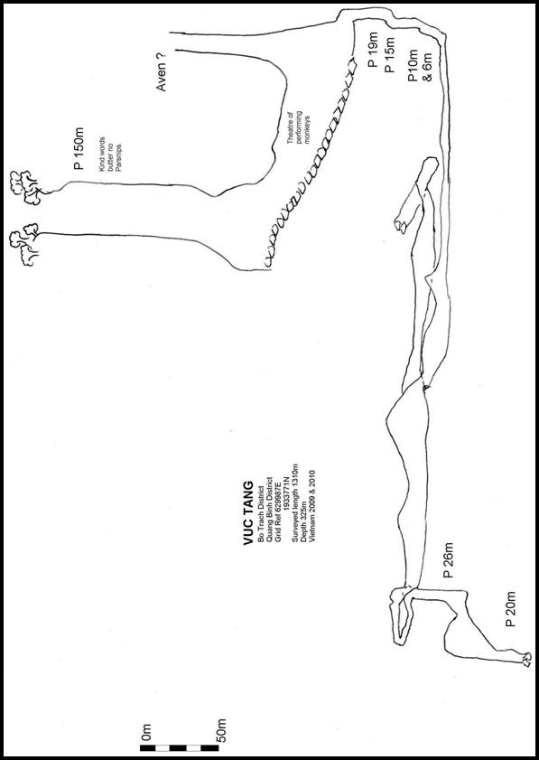
Yellow Cliff Caves
From the bridge over Chay River at Son Trach, we followed the road towards Cha Noi for circa 13km. We turned left on to dirt track through village and past fields to a large shade tree near a river. The path followed the river upstream past a swimming pool then over a couple of fields. The way then heads west steeply up and over a col to a valley with a small river. We continued following the path on the east side of the river heading south. After several hours you reach the cave in a low cliff. The entrance cannot be seen from path. A small stream sinks in boulders at the foot of the cliff.
We scrambled up over boulders to enter the cave on a high level platform. The stream can be reached at a couple of places by easy downwards climbs. Upstream quickly leads to boulders, with water emerging from between them. Down stream becomes lower until it emerges into daylight, where the water joins a surface stream in a steeply descending gully.After exploring cave it appears that the cliff is one side of a ridge of rock with the cave passing right through.
We traversed north along cliff for about 30 metres. A scramble up behind a flake of rock led to a second cave entrance. Easy walking rift passage leads directly through ridge to emerge into daylight well above the exit to Cave1. The passage is dry and is likely a former, higher level, drainage route. Plenty of bats were encountered! The third cave entrance is an open sided arch circa 20 metres wide and 30 metres which leads through to an exit.
Ledges at different levels have been cleared as sleeping platforms and fire pits indicate occasional past use as a shelter. A small alcove shelf held a fragile earthenware bowl of circa 30cm diameter. This was left in place. The cave is probably the site of earlier drainage development as it is located well above both Caves 1 & 2.
Martin Colledge
Hang Billy
Mr Khi was keen to show us yet another cave deep in the jungle which transpired to be the exit of Maze cave. However this enable Sweeny and myself to return to Pitch cave and relocate the missing entrance of 2009 also confirming that looking for a 30cm opening I n a jungle after a ten years is not a good idea. Whilst camping in the river bed Khi pointed out a small cave on the opposite bank of the river. This was a short through cave with little interest, or so we thought. The cave actually exited in a dry river bed which we eagerly followed. The river bed was a tributary to a larger river which was also resurgence to a large cave. The cave began with impressive proportions but soon narrowed to a rift. Exploration fever had taken over as we waded with excitement over deep pools forgetting that we had cameras in our pockets. Finally the passage closed down after 140m.
Martin Holroyd
Hang 18
Hang 18 was so named because it is accessed from kilometre 18 on Road 20. It was described as a river cave, very close to the road, so we were quite keen to check it out.
We made our way up to kilometre 18 in the jeeps, with Khanh and Nguyen as guides. Arriving at the right spot, they set about clearing and marking a trail down to the left. After about 20 minutes or so, we did arrive at an entrance with a steam clearly visible about 15m down.
Our guides left us there, setting off to look for another cave. We donned wetsuits as it was quite a sizeable steam. Descending the boulder slope, the downstream passage sumped almost immediately. The passage continued to the right for about 50m before dropping down into a swim, which sumped after 15m. A dry side passage above choked after 20m or so.
It was now raining as we headed back to the road, following our guides notches and bent twigs. Needless to say it took us a couple of go’s, but we were soon back at the road. Eventually our two guides reappeared, but they had been unable to locate the second cave, so it was time to return to Son Trach.
Deb Limbert
Hang Noi Bu
The first trip to Noi Bu with Martin Colledge and Adam Spillane involved an easy walk of some five hours with plenty of rest stops until a steep descent into an enclosed valley. Excitement levels were high as this was our first trip of the expedition. I became more excited on approaching camp to find a running stream, which I had not expected considering we were high up on the karst. It appears that in this area there are some large areas of steeply inclined sandstone beds that provide a chance for the caught water to gather and flow off to where the sandstone meets the limestone.
An old camp site was occupied, and improved upon, next to the stream. Hammocks set up we were impatient to go and look at the cave. Our guide bat man led us down along the stream to where it disappeared in shingle and boulders. A short way beyond, a climb over larger boulders revealed the entrance to Hang Noi Bu. A roughly 10m arch led down some climbs to the head of a pitch. Things looked interesting for tomorrow’s exploration.
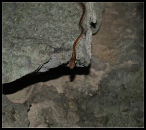
An early start the following day saw the first drop quickly rigged to a large ledge where a pitch dropped away into the blackness. With no natural belays, and no drill, I looked around for an alternative descent. Behind and under the entrance pitch some holes in the boulders revealed an alternative hang with natural belays. Unfortunately the route was guarded by an angry looking snake on a nest with eggs in it. The belay was just above, and a quick jump through the hole and onto the rope managed to avoid a bite.
A couple of rebelays saw us at the bottom of a 26m pitch. A tall rift continued down a couple of climbs to the edge of a very big pitch. I had a quick look over the edge but judged it would be better rigged with a drill. It looked superb dropping away far beyond even the reach of my powerful Hope light.
A return along the rift revealed a small side passage that led over calcite false floors to a 4m climb that needed a rope. The continuing passage quickly enlarged to the edge of another impressive pitch. This one looked a lot more clean washed, extending upwards as well. Debris on the side indicated this was the sink when the surface stream was in flood, sinking beyond its present position.
It was Adam’s turn to drop some pitches, so after evicting a large rat from its bed behind a fine natural belay, he set off down. The pitches that followed were all in superb smooth polished grey limestone. Adam made good use of chock stone boulders to rig several pitches until our 100m of rope ran out on the lip of another big drop. Trundling rocks returned a great echo and expectation was high for a return visit. Martin set off back up the rope first, hoping that ratty was not making a meal of our nice new rope tied around its nest.
It was probably 2 weeks before we got the chance to return with so many other objectives to look at. At last Robbie Adam and I were walking back up the trail to Noi Bu. Sadly Adam was feeling sick and decided to return to base. This left Robbie and I to grab all the glory. By pushing the porters on we managed to reduce the walk to 3 hours, and soon had camp set up again. Impatient to plumb the depths, we were soon back at the entrance. Drill in hand the initial pitches were soon rigged clear of our unfriendly snake. Feeling that I had probably grabbed more than my fair share of pitches, I passed the drill over to Robbie. We decided to descend by the original big pitch as the survey seemed to indicate they would join at depth anyway. The bigger drop would probably also use less bolts.
Robbie was soon happy in his work. I watched his descent with envy as deviations went in and gradually he disappeared from sight. Soon the call came to follow down the magnificent shaft where avens joined, finally landing next to an excited Robbie at the top of another pitch. I was graciously re-assigned the drill. Descending a steep calcite ramp, I landed on a ledge above what looked like a final 15m drop. A quick rebelay on some stal bosses and I descended into a large passage going off into the distance. United we decided to make a quick dash down the passage to see what might be in store for tomorrow.
The passage was about 8m square with a lot of mud coated stal hanging from the roof. Going by the mud banks on the sides the whole cave probably fills to the roof in flood. Convinced we were in for a big day on the morrow we decided to exit as the day was now getting late. The walk back through the jungle in the dark was full of expectant plans and ideas of where the cave was headed.
Our guides were pleased to see us back with our news and shared their rice wine with us around the camp fire.
Heavy rain came in overnight, but this did not stop us being back at the entrance by six thirty. I turned my light on, only to have it give the battery low signal. Cursing I changed to my spare only to get the same signal. Now down to my backup Myo, I tried to catch Robbie up. Back at the big pitch as we started the survey Robbie revealed he had no back up light, so I was a little apprehensive about a long trip. I need not have worried! Only one hundred metres beyond our previous days limit the roof came down to a dirty sump. With much disappointment we de-rigged and were back in camp by ten thirty. It was hard to believe an entrance and obvious sink like this could end so soon. The running water from the valley was never seen in the cave. Had we been at home in the Dales, no doubt we would have been searching the river bed for the wet entrance. Still the cave had provided plenty of excitement of a vertical nature and is surely only an indicator of more to come in this new area.
Mick Nunwick
Shaft at Kilometre 30 Road 20
In between our multi day trips, we took a trip to kilometer 30 on our old favourite the Ho Chi Minh trail or road 20. I had not travelled this way since 1990and enjoyed a road mainly free of bumps, and surfaced as far as the old war shrine. The track beyond deteriorates, but can now be negotiated by a four wheel drive jeep. After much bouncing around, we arrived at K30. Our guide and his mates led a team of myself Andy Mackenzie, Robbie Burke, Robbie Shone, Carsten and Phuong off into the jungle. After 10 minutes a halt was called whilst the Vietnamese went in search of our objective. Carsten passed the wait by taking some posed walking shots, before shouts and whoops confirmed the shaft had been found.
Ten minutes steeply uphill, and we arrived at the lip of a very large shaft some 20 metres across, with a large arched roof on the uphill side. The floor could be seen sloping away into the darkness. It looked very promising, and as I was carrying the drill, I pushed to the front to claim pole position for the descent. After a few tree roots were cleared, I placed a couple of bolts, Andy handed me a big bag of rope, and down I went.
The walls retreated and soon I was abseiling in the centre of a large chamber. A large bat colony clung to the roof, and beyond them I could see another small daylight entrance. Touch down was made on a steep slope. Leaving the rope behind, I continued the descent down steep calcited slopes into a larger chamber. Unfortunately at the limit of daylight the cave ends abruptly with walls on all sides. A disappointed return was made, noting the many formations. The pitch was about 50m, with a similar descent over a horizontal distance of about 100m. The chamber was some 50m wide in places.
Mick Nunwick
Phong Nha Side Passage
Whilst the attempt to re-visit the end of Phong Nha was ultimately thwarted by rising waters just before The Pagoda, we did manage to check out any obvious side passages from Uncle Ho’s Chamber to just before Turd Hall.
A previously un-noted passage on the left-hand (east) side beyond Kneecrunch Inlet, but before the swims of The Black Lagoon, gushed clear water out into the main brown- stained river. This resulted in approx 650m of interesting walking/stooping/crawling/ducks in a mostly comfortable 3m x 2m passage concluding in a terminal sump preceded initially by 2 side sumps shortly before end. All 3 large/clear & eminently diveable although insertion into the cold waters resulted in large clouds of slow clearing silt.
Further trips might well result in more discoveries off the main passage.
Loong Con
Loong Con can be found by following the path from the dry river bed up to the top of Garden of Eden doline, a further 45 mins walking along, at times, karst hopping terrain leads past an old hunters camp to an obvious 15m x 15m doline entrance dropping straight down as a 65m pitchinto a huge chamber.The entrance pitch is a fantastic, rigged off a thin tree on the very lip; the rope drops straight through the ceiling of a huge chamber, a bit like dropping down into St Paul’s Cathedral but a lot bigger. No abrasion at all which was just as well bearing in mind the bouncy characteristics of our 9mm rope. As you descend, the walls of the chamber speed away & you begin to get a grasp of the huge size (150m x 150m?) plus the number & size of the various calcite bosses sprouting up from the chamber floor. At the bottom the floor rises to some magnificent stal formations before dropping steeply down over broken boulders from the roof above. Strong rays of light pierce the chamber as the sun passes overhead creating an almost laser-like spotlight exposing hidden corners. A quick look around the perimeter reveals only 1 obvious continuation, a drop down through boulders on the east wall. Initially this was dropped down 2 x 10m pitches ending in a further, drafting, 15m pitch before lack of rope stopped play. A return with extra rope & an electric drill meant a safer descent & the 15m pitch was pushed plus 2 further 10m pitches (unsurveyed) before the cave ended in a chamber with a very strongly drafting, but miniscule, rift. Digging, battering the walls with lumps of rock, stopped once we cast an eye upwards & discovered sofa sized perched boulders staring back with malevolent intent. Loong Con is in a very interesting area being above & beyond the end of The Alcove in Hang Son Doong, our geologist had previously indicated that there should be further cave. If the draught is anything togo by then it might be worthwhile spending further time exploring the large wall/floor perimeter or seeking further surface entrances. No surface or underground water however means that camping can be problematic if intending to stay for more than a couple of days.
Sweeny
MINH HOÁ
Hang Ken/Tu Lan
By chance whilst trying to find a map of Quang Binh on the internet I found a link on caves of the Minh Hoa area with articles of large river caves 6km long and still continuing. Howard had identified this as an area to return to in 2010 and this article further confirmed the potential. Previously visited in the earlier expeditions very little had been done in the area with only a handful of discoveries to date. A small recce team of Phong, Deb, Sweeny and myself headed off in search of the guide who featured in the web article. By chance we were directed to the town of Han Mho situated in stunning scenery, a mixture of Emerald green paddy fields, cultivated farm land surrounded by stunning tower Karst. The usual ritual of chasing permissions resulted in an interesting night on the Vice Presidents floor and a bleary eyed team set out the following day. From the town of Tan Hoa it is possible to drive across the fields to the north of the village and the Song Nan River. When the cultivated fields prevent further vehicular access a pleasant walk crossing the river and paths through the maze fields led to a sink with flood debris high above. The cultivated area borders the jungle and gives a fascinating contrast; a good path led us through the jungle with the obligatory hills, exposed climbs and biting stinging bugs and plants. We dropped steeply to an impressive enclosed doline. The impressive resurgence of Hang Ken is obvious on the left as the valley floor is reached. A GPS fix and referenced with the map put us in a small enclosed doline but no river was marked which was odd as the large river bed and existing river would appear to be very significant Convinced that the map or GPS must be incorrect we wildly speculated and tried to make the landscape fit the map and the marked rivers 2km to the north. We had however arrived at a stunning location and a camp ground soon formed and the pot on. The trees for the hammocks were shallow rooted as I was soon to discover, when testing the hammock the tree uprooted and a hard landing was only avoided by the lighting reactions of Sweeny supporting the tree(primarily for self preservation as he was in the direct fall line) did I get some stick!
With a choice of caves we chose Hang Ken the large impressive resurgence upstream of our campsite.The entrance is easily reached by scrambling over boulders to an impressive entrance arch 15m high and 30m wide.I had already chosen to put on my wetsuit at the camp ground much to the amusement and ridicule of the others. The large entrance lake however was hidden from view until an easy scramble up the boulders revealed the true beauty of the cave and of course the lake, my turn to laugh. Caving with Sweeny is always educational and full of Innuendo’s. Soon Hang Ken was linked to Coronation Street and Deirdre. What?Picture the scene, an easy swim across the lake with Sweeny (egged on by Deb it has to be said) in full fantasy innuendo, wet passage, doggy fashion and I sang the infamous Toy Dolls song Deirdre is a slag. An obvious bend in the river with a large dry passage above brought an immediate reaction from Sweeny“ I wonder if Deirdre is a goer” The passage was aptly named but would wait for later. The main river passage continued in fine style with numerous swims, occasional climbs and cascades. The end of the cave changed abruptly and the main flow may have been missed. The river passage ends at a large shingle bank and the source of the river is lost. Ahead the passage splits into smaller passages, a wet canal on the left appears to double back on itself and was only explored a short way with no conclusion. Ahead the passage ends at a large calcited breakdown area. A route was found to the left and appears to be a sink inlet this was followed for about 250m to a complete choke but evidence of roots and surface debris.
Back on the surface we settled down to cooking the dinner on the open fire and stubbornly insisted on boiling the brew water on the spluttering fire rather than the primus stove, we went to bed late!
Our objective the next day was Deirdre is a goer, or, as we joked would she have a headache? The passage was easily reached by a simple climb up calcite to a large impressive dry passage starting as an easy walk passing many large calcite formations. The passage becomes smaller and the obstacles more abundant, climbs across boulders with friable hand holds, slippery mud and sharp blocks along with cold pools of water that are a mixture of wading and swimming to cross. The passage closes down dramatically and just when it appeared to be finishing dramatically drops into a large active river with a strong current. Time was now against us and we made the decision to see if the river might be the unexplored cave back at the Doline, a short recce confirmed that this was a significant passage and daylight could be seen in the distance, however the flow was the wrong direction so we could not chance going out this new way and returned the way we had come.
This had been a stunning recce with over 3km surveyed, going leads and hitherto unexplored caves.
We soon returned along with Howard, Anette, Carsten and Robbie, this time to explore the sink of Tu Lan. Howard was amazed that we had left such an incredible sized cave. The first trip saw Sweeny and me paired up to push the stream, Howard, Deb and Anette to survey the dry entrance and the Nat Geo boys to take some photos. The dry entrance connects to the streamway a short way downstream where we found the trio sat in darkness to avoid the swarm of flies and moths being attracted to the lights. The survey was connected and we left the others to take photos Sweeny and I set off downstream. The moths were unbearable and at every opportunity we would switch our lamps off. It was whilst sat in the darkness I heard the sound of something swimming close by. I was initially startled when I switched my lamp on to see what appeared to be a snake swimming towards me. On closer inspection the flattening of the tail reassured me that it was most likely an eel, or so I convinced myself. Swimming downstream in a large river always fills me with trepidation even more so when you can hear the roar of water downstream as we continued our exploration. The source of this sound was a massive gour dam filling the passage and the water being forced through a small hole in the calcite. Immediately downstream the current was strong to swim against so we found a devious traverse route along the wall. Ahead we were faced with more swimming and again the roar of another set of cascades. These cascades made a magnificent picture. A double cascade created again by a massive calcite dam. This provided a logical place to end the day. The following day saw an early start as Anette had to leave the jungle that afternoon and enthusiastically she was maximizing the full potential of caving time. The remainder of the team headed to the new upstream cave of Hang To Mo which was a magnificent entrance but sumped only a short way in. From the previous limit Anette and myself continued the swim downstream, passing a ‘duck’ we continued to swim further and further and still we swam until we finally reached the third calcite barrier. Here a massive boulder slope tumbled in from the left which was not pushed. More swimming led to another massive calcite barrier. Again the water crashed noisily down a 12 m waterfall to a pool below. To reach the pool required a climb where a small inlet passage joined the cave (this was not explored). A short distance forward the way was blocked by another calcite dam, to reach this required a high level traverse. The way on dropped steeply to the water below but this time there was no cascade and it appears to be a sump. This was not conclusively confirmed as it would require a line to descend the calcite barrier. It was time for Anette to leave, only now did we appreciate the length of the swim between the second and third calcite barriers. In the far distance we could make the lights of the others taking photos, for almost a kilometer we swam, Incredible!
Martin Holroyd.
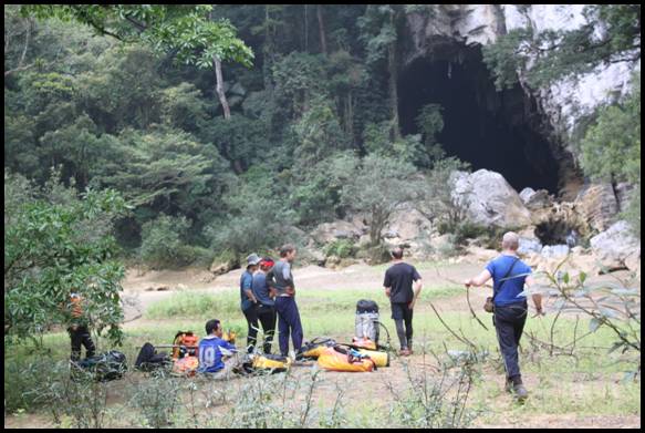
HANG TO MO
Having been very lucky to find two going river caves in the idyllic valley of Tu Lan, we decided it was time to look at the upstream entrance in the valley. The water resurging from this cave enters Hang Tu Lan.
Our guide took us to the entrance through the forest which was a lot easier than having to wade upstream. The water emerges from Hang To Mo to cascade down several tufa dams, a very beautiful place.
Wading in from the dams soon led into a swim. Across the other side of the pool, we climbed out, and proceeded through flowstone for about 10m to a drop into another pool. We could see flowing water at the other side, however the passage was quite small.
We dropped into the pool, and swam the short distance to shallow water. The current here was very strong. Ducking under an arch, we soon came to the sump, a small pool with a very fast flow of water issuing from it.
Deb Limbert
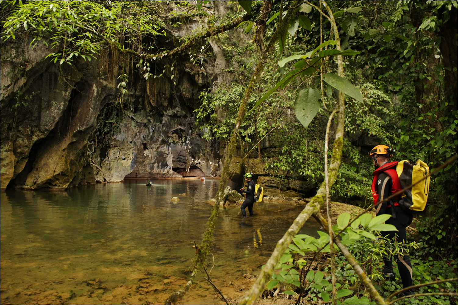
Photo by Carsten Peter
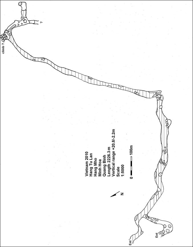
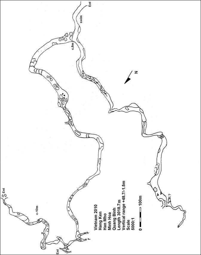
HANG VUUC
Mick, Phuong and I set off round to Minh Hoa district, to return to the village of Cha Lo, and hopefully pursue some of the leads left from last year. When we arrived in Cha Lo, we checked in with the military post, as this area is close to the Lao border. All seemed well, so we went for lunch in the local café, and tried to locate the guides from last year.
None were available and we were advised to wait till late afternoon when they would return from the jungle.
Phuong and the driver promptly went for a siesta and were soon snoring away leaving Mick and I to twiddle our thumbs. About 4pm we woke Phuong up to see if there was any news of the guides. He wasn’t feeling very energetic, so Mick and I decided to walk back to the café and see if we could get a cold drink.
Within 5 minutes we were approached by an army man appearing out of the bushes. Unable to explain we’d already spoken to the military, we took him back to Phuong who explained, and he duly recorded all this in his notebook. Setting off to the café we were stopped almost immediately by two more military. Phuong appeared with the minibus, and said it was best if we drove the 500 yards or so. We got our drink, and the military kept popping in to make sure we were there, until they’d obviously got the all clear, when they finally disappeared.
After dinner, we returned to the house of the local president, to see who was around. Unfortunately none of the real jungle men were available, but there were some local lads who knew how to get to Hang Vuuc. According to reports this had a large chamber which could fit a battalion of soldiers. As this seemed to be the only option, we made arrangements to go the next day.
After a night with no sleep due to loud TV, road works involving spraying tar all night, and various biting insects we were more than happy to head for the jungle!!
The way to Hang Vuuc involved driving 2-3k out of Cha Lo towards the Lao border. We then took a path on the left of the road, and headed into the forest. The path was well known as it had been used during the war for communications. After half an hour or so, the path began to ascend steeply. Near the top we stopped to wait out a heavy rain shower. Descending the other side, the way continued level and very pleasant for an hour or so. We crossed a fallen tree, and almost immediately our guide realized he’d gone wrong! We came back to the tree, and then proceeded to climb steeply up with no path, clinging on to whatever was available to avoid sliding back down! After 20 minutes or so, we arrived at a small cliff with an even smaller entrance.
Not feeling very inspired, we ate some of Mick’s stash of chocolate bars, and set off surveying. The entrance lowered to and hands and knees duck through into a small chamber. This was well decorated, and dropped via some stals into a lower equally well calcited chamber. A first glance showed no obvious way on, but we continued to survey to the far point.
Phuong showing some initiative was climbing in the stal on the right. He shouted that he thought there was a passage but he couldn’t climb down. Leaving the survey gear we went for a recce. Climbing through the flowstone led to a short drop down, and then into another short crawl. The good thing was it had a good draught. However this can always mean another entrance close by, so we weren’t too excited yet. After about 50m of walking passage full of stal, and about 3m wide we emerged at a T junction with a much larger passage. The passage was 25m wide, and appeared to go left and right, however both ends calcited up pretty quickly. A dark hole opposite where we had entered needed checking and after climbing over some stal we walked into a much larger chamber. The floor was covered in shallow water filled gours, so at least we had a water supply. Across the other side of the chamber the passage continued.
Returning to the entrance chamber, we quickly surveyed into the new stuff. The passage continued to enlarge, and was full of stal columns and flows. The passage was 20m by 20m, and again ended in a calcite choke after about 100m. There was a spectacular shaft on the left, which was completely covered in calcite flows. It appeared to be at least 20m deep, and could not be descended as we hadn’t enough rope. It is likely to calcite up, but might be worth a look.
Mick had spotted a possible passage on the right, it appeared to head back towards the entrance, but soon was obviously a separate passage. Ascending over ‘popcorn’ encrusted boulders we came into a large chamber full of beautiful stal and active gour pools. The passage ended in calcite straight ahead, but Mick had been off again, and found the way on to the left. With great enthusiasm he described the draught and the start of an enormous passage.
Surveying into the new passage we went through a narrowing where the passage was about 5m wide and 4m high. The draught here was very strong. The passage enlarged to 15 and then 20m wide, still full of stal. We could see the roof arch ahead, and after that just blackness! We emerged at the foot of a huge boulder slope. We surveyed up the steeply ascending boulder slope for 200m. The passage was 100m wide, and 40m high from the boulder slope to the roof. Sadly there was nothing at the top, but calcite. There were some small gaps but we had lost the way. We spotted an arch lower down on the left, but this only went for a short way before calciting up.
Determined to find the source of the draught we scrutinized the right hand wall. About half way back down we spotted a possible roof passage about 20m up. This would require bolting. Talking to the locals when we exited, we learnt that there was talk of another entrance. The size and development of this cave suggests that there are major caves to be found in this area.Hang Vuuc is 800m long, and ascends over 100m from the entrance to the top of the boulder slope.
Deb Limbert
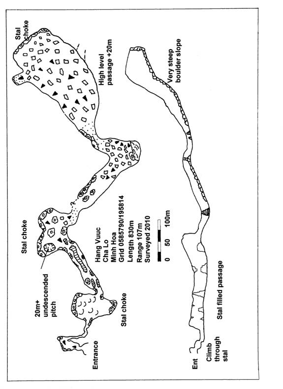
MEDICAL REPORT
This year’s expedition had extra hidden problems, in that having a National Geographic film crew and photographic crew plus the added extra porters meant we had to get the medical kits right.
In Hang Son Doong at the beginning of the trip a few of the team had problems with eye irritations, ranging from watery eyes to very inflamed red eyes, causing discomfort. All the eye complaints responded to chloramphenicol cream or drops.
Sneezing and a bad cold also seemed to do the rounds, with five people affected, making for a miserable few days. For one or two people it lasted a bit longer.
On offer this year was some quite serious walks for up to eight days and on most of these walks we experienced a lack of water. We had to resort to cutting vines and draining the water out of them, and cutting banana trees, and collecting the water from the stumps. It was felt that a number of cases of D&V were caused by dehydration, and the lack of being able to rehydrate properly. Meal choices often had to be restricted to those which would use the least water e.g. boil in the bags, so carbohydrates such as rice and pasta were eaten sparingly.
One member of the expedition brought with him a foot with several screws in it, which didn’t perform very well. The foot swelled up quite badly, so anti inflammatories and paracetamol were taken. Also 1000ft down a cave the same person (who will remain anonymous in this article due to medical confidentiality) suffered an attack of very severe cramp in both legs, probably as a result of dehydration. He had to be helped up every pitch with good friendly teamwork, until the surface was reached and he was then called a big fat b*****d. A muscle relaxant was taken that evening so he could get into his hammock!
Other usual expedition issues such as harness rub were dealt with by Sudacream.
One person had a bout of gout, which puts paid to the old wives tale of too much red wine. It resolved with rehydration.
Another small problem was burnt hands from PF300 flash bulbs exploding as they were loaded into the firers. Gloves essential. These were treated with burn cream/gel.
Only one telephone call back to our friendly GP John Burton was needed, for advice in connection with bites. One member had small bites around the ankle and foot, which swelled rapidly with fluid, and ulcerated within the hour leading to open sores. These were treated with iodine dressings, and soon healed. Some scars remain.
The youth of the expedition came back with descent rope burns on his neck, unless he’d been up to something else he hadn’t told us.
Bad backs were a problem, for a couple of people stopping them caving for a few days.
As you can see no major problems, but one feels we have to keep on top of safety and dehydration on future trips.
This year’s sick note award had been awarded to:
Adam ‘sick note’ Spillane with Ian ‘big foot’ Watson a close second. Third place goes to anyone who wants it!
A serious thank you to Dr Nick Howlett, and Dr John Burton, for their help before and during the expedition.
Ian Watson.
EQUIPMENT REVIEW
For this trip we were generously supported by Lyon equipment who supplied a number of Petzl Ultra head torches and Exped rucksacks which were used extensively throughout the expedition.
The Petzl Ultra gave exceptional performance in the large cave passage and proved to be robust in the harsh environment. The switch was easy to use even with gloves on. The batteries had a good life span and a range of settings for the light output.
The Exped sacks were used extensively for porter loads both above and below ground and were seriously abused. Whilst not designed specifically for this task the sacks lasted the expedition and were showing signs of wear and many had been punctured. Where the sacks were used for personal use they tended to survive the trips and proved to be extremely good for keeping personal belongings dry in the wet environments.
Seal Skinz generously provided socks for all the team members. These are particularly effective as leech socks.
Diary Photo Trip 24/4 – 6/5 (I was Carsten’s Bitch)
Sat 24 – walk & camp HE(Hang En) – student tourists – gout
Walk to Hang En with about 12 porters, numerous boxes of flashbulbs etc. Camped in downstream entrance of HE as had about 8, young studentVietnamese “tourists” visiting entrance of Hang Son Doong. Easy day spoilt by short gout attack in late afternoon brought on by dehydration.
Sun 25 – HE, photographing 2nd & final chamber – swift – green boulders – pancakes
Day started with breakfast pancakes before the eggs went off.Carsten photographs the chambers on route to the upstream exit, his meticulous & time consuming approach a foretaste of what is to come as is his ability to see good photo opportunities in the mundane. A baby swift, presumably taking its very first flight, crashes into the lake in the 1st underground chamber & had to be rescued from a watery death. Attempts to photo large calcite walls/gours proved largely unsuccessful
Mon 26 – Pancakes – photos under scallops – Starlight HSD – rained 3am onwards – water from below ent pitch
Finished off last of the fresh eggs with pancake breakfast. Packed kit for move to Hang Song Doong.Raining heavily from 3am onwards. Carsten took some interesting looking shots in the heavily scalloped passage between 1st & 2nd chamber before we set off around mid-day for HSD, looking at gully leading to Khe Ry on the way. Cosy camp set up in HSD porch, “Starlight”, entrance pitch rigged as a protected climb & water collected from the underground river below. Porters cook wonderful meal of pork & rice
Tues 27 – 2 river crossings – 4 porters taking loads to LPF
Down to the river & both crossings rigged with tensioned tyrolean’s, 4 porters pass taking loads to the next camp at Level Playing Fields.Carsten spends hours taking photos of both crossings from various angles including from underwater.Camped again at Starlight, porters cooked beef & rice – superb.
Weds 28 – Hand of Dog – LPF Camp – water in rift – thunderstorm – water higher
Woke up to a monumental thunderstorm, cloud rolling down into the entrance slope. Starlight camp remains dry & squirrel noted foraging in trees. Camp broken & loads taken into cave with intent to set up new camp at Level Playing Fields. Water levels have increased.
Carsten asks that I make my way to top of Hand of Dog, 800m in distance & flash forward. We are down to just 3 w/talkies between 5 stations (1 w/t taking an early bath during the river crossing photos) so agree rudimentary signaling system using lights. Hand of Dog easy climb onto 1.5 x 1.5m tabletop. I’m then on this for over 4 hours(!!!) as various photos taken. Unable to express dissatisfaction with time taken as no w/talkie & flashing my light in an agitated manner fails to produce satisfactory, indeed any, response.
Finally, circular light movement indicates photography finished & perch can be abandoned. Make way to LPF, dump kit & make way back to help carry gear.
Carsten forbids open fire cooking at camp so as to maximise chances of keeping the cave clear for his large passage pictures. This doesn’t go down well with the porters & we end up cooking own food on petrol stoves.
Thurs 29 – RCS 30 – ropes stolen – photo across gully – new pass – 2 more porter loads form entrance – S/Pen stops working
Robbie is 30 today. Happy Birthday. 2 porters bring in surface loads & advise the entrance pitch ropes have been stolen! This is the 2nd time & is a worrying situation as 1 porter already slipped on entrance climb & it’s not difficult to envisage a serious accident taking place.
Carsten photographs back towards entrance, I’m situated down in gully where river can be heard roaring below. Porters dressed in Carsten’s orange ‘Gitmo’ boilersuits. 3 hours later, numerous exploding f/bulbs having been heard in various locations in the meantime & can now move position. Check not needed for next shot & take opportunity to look at where the water is going. Climbing down it is apparent that the water course is still a place of extreme, active violence. Huge boulders are closely packed & scatter-gunned up into the roof & any side rift. Progress is made via squeezing, climbing & bridging downwards through a huge rock maze. A offset chamber has a stream running through & an obvious inlet passage coming in at 90 degrees, approx 10m x 10m the passage is initially jammed with boulders but then changes to open passage. Conscious that I’m by myself & have been away for almost an hour, a return is made. Some route-finding difficulties in trying to climb out of the packed boulder jammed passage & into the open gully above, couple of failed attempts before finally finding correct way out. Climb back to LPF, photos now being taken at moraine between LPF & Watch Out for Dinos.
Back at camp for 7pm. 2nd night without fire & once more have to resort to boil in bags.
Robbie et al consume 3lt of the 5lts of rice wine brought by the porters for his birthday. As an old man I take to my bed early & thus miss the ensuing chaos.
Fri 30 – Collect Martin & Kangh – genny to Beach – talc bath –
5:40am start for Howard, Deb & myself as we make way from LPF to collect Martin (Nat Geo graphic artist) & Mr Kangh. Up new, & easier, route across the difficult terrain opposite. Rigged both climbs down & up above the wet pitch. Down Watch Dinos, along Ratrun & up into Garden of Edam, the rope previously rigged from the surface showing up clearly in the daylight. Past the Beach & into the start of Passchendaele before arriving at the start of the 86m climb up to HSD exit where we due to meet Martin & Kangh at 10:30am.
Howard’s hand still painful from earlier fall (torn ligaments) & he elects to stay at the bottom of the rope climb whilst myself & Deb collect our visitors.
They turn up at mid-day, their ascent up the hill pushing a troupe of long-limbed monkeys in front of them into & across the entrance providing us with a perfect view as they silently flee across our field of vision.
Both carrying large packs + spare rope & a half-sized suitcase containing Carsten’s specimen Petri dishes. Introductions, share gear & make way into cave. As Kanghs only previous abbing experience is 40mins outside hotel couple of days ago, & with a hanging belay stance to also contend with, clip cows tails into his harness & ab with him down separate rope.Back up to ensure Martin ok with changeovers before returning to help with bags.
Start to make way back to LPF, collect film crew’s generator from camp before Passchendaele & take to Beach Camp where same fired up & batts put on charge.
Finally back to LPF camp at 5pm & the delights of a full body talc wash. Doesn’t get you any cleaner but smell becomes temporarily more bearable.
Sat 1/5 – down to Burton – thunderstorm – floodpulse –
Pack kit for moving to Beach Camp, into Watch Dinos for pictures. Heavens open & rain pours down. And down. Flood pulse comes through like a roaring train, waterfalls appear from high up in roof & Carsten has a field day with the exciting new perspectives. Note new rift passage, check it as an ongoing lead then return to it with Martin to explore downwards slanting tube. Ends at a subterranean river but I recognise this as being the beach reached from the Wet Pitch & explored up to Going for a Burton. At least we now have connection avoiding necessity of the Wet Pitch & the subsequent 20m pitch.
Back up & into start of Ratrun, Carsten has idea for a picture with a light shining directly up from the base of a newly appeared waterfall. Agree fee of limitless cocktails & beer in Sun Spa & proceed to get very wet.
Sun 2/5 – fish/shrimp – photo Rat run – break boots
Howard, Deb & myself play at great white hunters & set off to capture white shrimp & fish for Carsten’s photos.
Photo Rat run & then spend couple of hours up the 70m pitch of Garden of Edam whilst Carsten struggles with condensation in his camera whilst trying to take pictures from a slightly higher perspective. Eventually he has to abandoned attempt & I arrive back at Beach Camp just as it’s getting dark.
Discover that right 5.10 boot has come apart after 8 weeks of caving. Luckily, if somewhat bizarrely, Phuong has brought spare pair of Howard’s Hi-Tec lookalikes & they fit!
Mon 3/5 – photo down gallery to Passchendaele – rift – Cormorant
Spend the morning photographing The Sublime to the Ridiculous. Explore the “Pit” on left-hand wall. Manage to climb down about 12m onto a jammed boulder & pitch continues for at least same depth below. Stone thrown down could be heard to land in pool below.
In early afternoon helped with 2nd look at Cormorant. Amusing climbs up & down increasingly slippery slopes, flat out squeeze into small closed chamber & draught lost somewhere along the way. No obvious way on noted.
Back up G of E 70m pitch for Carsten to attempt further photos.
Tues 4/5 – Passchendaele – drilling – How/Martin exit
Photographing a very muddy & considerably wetter Passchendaele. Robbie comments that Little Jonnie not very happy with the higher water levels. At the Wall take various drilling shots. One bulb blows whilst Howard screwing it into firer, now has both hands damaged. Decide he will go back to Beach to collect burn bandage & then continue out to HSD Starlight Camp with Martin who is due back in Hanoi in 2 days time.
Meanwhile Carsten & Robbie, Deb & myself continue with the photography showing the former the wonderful Pearl Harbour passage & the magnificent array of cave pearls. Carsten & Robbie make such voluble appreciative noises that I begin to suspect their appreciation of karst geomorphology may have taken on a somewhat worrying & unnatural bent.Photo the calcited skeleton found on the original exploration & then onwards to the daylight exit 650m forward before returning back to Passchendaele & Beach Camp.
Very little food for the 4 of us not helped by the cooked spam falling into the sand. However quick rinse & patting down with (unused) toilet roll salvages situation.
Weds 5/5 – Beach – gear –
Spent the morning photographing across the Beach Camp & then down into Cormorant before Carsten spent some time taking “experimental” shots depicting moving in cave, these shots in particular caused the firers no little consternation as the bulb guns fire automatically, & with no warning, as opposed to a manual fire.
Afternoon Carsten & Robbie off photoing biology specimens whilst Deb & I dig pit, burn rubbish. This takes hours but excellent job done.
In afternoon ferry large bag up 70m Garden of Eden pitch, store at the first star 10mm rope belay & de-rig the 9mm rope. On slow prussik up, large flying squirrel detaches itself from about 2m above my head just at the point where the roof is met. Large membranes stretched taut between wrist & ankle make it look like a large leather box-lid as it glides down & upbefore landing halfway down the wall on a small clinging tree, folding it’s wings it practically disappears as its size greatly reduces.
Evening meal, pasta bursts through bag & follows y/days Spam. By now we are getting used to sand in meal & same given only a token rinse/clean.
Thurs 6/5 – exit & Son Trach – 2nd boot failure
Carsten & Robbie due to exit via G of E pitch so that they can visit Lon Kom whilst Deb & I de-rig HSD exit including the petrol generator, Howard & porters being due to meet us around 11am.
6.00am & we are off. Last trip through the squalidness of Passchendaele to the base of the pitches. We each have large bag of bivying/cooking kit plus drill + 2 batts + 200m of rope on the pitches + 16 boxes of flashbulbs + petrol generator etc etc.
Take turns prussiking up to first large ledge towing bags behind following abortive attempt to first carry bag on back. Tie-off & descend for next load. Sole of right boot peels of completely & have now wrecked 2 pairs. Unfortunately still over 650m cave & 90 mins of karst hopping & walking to get back to the road. Plastic support still in place but same has very little grip & climbing up the calcite becomes very frustrating.
All kit onto large ledge before final 8m verticality & 35m slope. Halfway up slope & the lights of 3 porters appear at the top. Step up slip, step up slip, step up slip. Towing rope handed over & they start to haul, however 200m & 6 individual lengths of rope results in a real dogs dinner & porters confused by which rope they need to take in on. Deb’s intervention tames the circus & finally everything is at the top but even with 5 of us, it’s still an awful lot of gear.
The walk with just1 boot is highly uncomfortable, particularly along the dry riverbed,but finally 2 hours later we are at the road where the air-conditionedmini-bus complete with cold soft drinks & beers awaits.
13 days & photography now finished. Can’t wait to see the results.
CAVES EXPLORED 2010
| Cave | District | Length | Depth |
| Hang Ha Lau (extension | Bo Trach | 1032m | 234m |
| Hang Lai | Bo Trach | 102m | 51m |
| Hang Noi Bu | Bo Trach | 660m | 165m |
| Hang Billy | Bo Trach | 142m | 10m |
| Hanh Khi | Bo Trach | 279m | 12m |
| Hanh Kho | Bo Trach | 86m | 10m |
| Hang 1987 | Bo Trach | 916m | 75m |
| Hang 1989 | Bo Trach | 693m | 59m |
| Hang 1990 | Bo Trach | 206m | 61m |
| Vuc 30 | Bo Trach | 35m | 80m |
| Hang Loong Con | Bo Trach | 210m | 97m |
| Hang Throung | Bo Trach | 38m | 0 |
| Hang Throung 2 | Bo Trach | 95m | 5m |
| Vuc Nguyen 1 | Bo Trach | 17m | 17m |
| Vuc Nguyen 2 | Bo Trach | 20m | 20m |
| Vuc Snablet | Bo Trach | 80m | 70m |
| Vuc 5 minutes | Bo Trach | Undescended | |
| Hang Trung 2 | Bo Trach | 59m | 5m |
| Hang 14 | Bo Trach | 30m | |
| Hang Du (extension) | Bo Trach | 427m | 90m |
| Hang Son Doong (extension) | Bo Trach | 876m | 108m |
| Hang 18 | Bo Trach | 108m | 13m |
| Vuc Tang (extension) | Bo Trach | 1106m | 93m |
| Phong Nha inlet | Bo Trach | 753m | 5m |
| Yellow Cliff Caves 1 | Bo Trach | 92m | 21m |
| Yellow Cliff Caves 2 | Bo Trach | 58m | 5m |
| Yellow Cliff Caves 3 | Bo Trach | 30m | 0 |
| Hang Tu Lan | Minh Hoa | 2226m | 23m |
| Hang Ken | Minh Hoa | 3683m | 71m |
| Dong Ha | Minh Hoa | 221m | 3m |
| To Mo | Minh Hoa | 68m | 4m |
| Hang Vuuc | Minh Hoa | 828m | 107m |
| Total | 15146m |

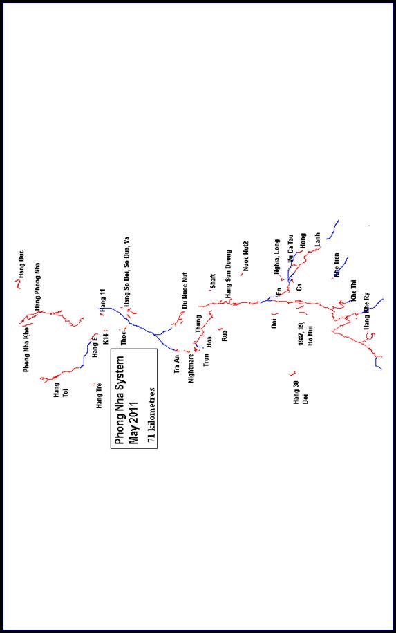